


Experts are predicting a double weather whammy in 2023 with the early arrival of solar maximum and the El Niño weather pattern, both of which promise weather instability. For aerial data collection, instability typically means more clouds, which can wreak havoc on image quality. Here, we explore the effects of El Niño and increased solar activity on weather, and why patience proves paramount in producing high-quality data that positively impact our clients’ bottom lines.
What is Solar Maximum
The Sun, our powerful celestial neighbor, goes through periods of activity known as solar cycles. One notable phase within this cycle is the solar maximum, which has a profound influence on Earth’s atmosphere and weather patterns.
The solar maximum refers to the peak of solar activity within an estimated 11-year cycle. During this phase, the Sun experiences increased magnetic activity, resulting in heightened numbers of sunspots, solar storms, and solar flares. These phenomena release significant amounts of energy and charged particles into space, collectively known as solar radiation.
Impact on US Weather
The effects of solar maximum on weather patterns in the United States can be substantial. While the precise mechanisms are still being studied, scientific research suggests several potential outcomes:
- Hurricanes and Tropical Storms: Solar maximum can potentially enhance the formation and intensity of tropical storms and hurricanes. Increased solar radiation heats the atmosphere and provides additional energy for storm development. This phenomenon has been linked to an uptick in hurricane activity, particularly in the Atlantic basin.
- Droughts and Floods: Solar maximum may contribute to shifts in atmospheric circulation patterns, leading to variations in precipitation across different regions of the United States. Some studies have suggested a correlation between solar maximum and drought conditions, while others have observed an increased likelihood of heavy rainfall events, leading to localized floods.
- Temperature Extremes: Solar radiation influences atmospheric temperature distribution. Though the direct impact of solar maximum on surface temperature remains minimal, it can indirectly contribute to temperature extremes by influencing atmospheric circulation patterns. This can result in both unusually warm and cold periods across different parts of the United States.
In line with the 11-year cycle, the next solar maximum was expected to arrive in 2025. But many experts are warning that this major peak in solar activity could begin by the end of 2023. The coming potential increase in solar activity is set to add to variances in temperature, which can result in conditions leading to more cloud cover than usual, sooner than later.
Exploring the Solar Maximum-El Niño Connection
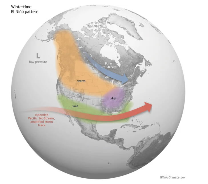
Compounding the effects of solar maximum is the arrival of El Niño. El Niño is a climate phenomenon characterized by unusually warm sea surface temperatures in the equatorial Pacific Ocean. National Oceanic and Atmospheric Administration (NOAA) scientists have been predicting a 90% chance of El Niño developing by fall 2023; the Climate Prediction Center and Climate.gov say that El Niño is already here.
While El Niño is primarily driven by these oceanic processes, some studies have suggested a potential relationship between El Niño events and solar maximum.
Research indicates that during solar maximum, changes in solar radiation may influence the strength and duration of El Niño episodes. These variations in solar activity can potentially affect ocean-atmosphere interactions, triggering or modifying an El Niño event. However, the exact nature of this connection is still an area of active investigation, and scientists continue to study the complex interplay between solar maximum and El Niño.
Regardless of any additional nudge from an early-arriving solar maximum, El Niño has significant impacts on global weather patterns. For the southwestern United States, including Texas, the El Niño weather pattern typically means wetter weather.
Wetter weather means more clouds. For client flyovers, this means data collection timing will necessarily take a backseat if we have to wait for a break in cloud cover.

Why Clear Skies Are Worth the Wait
Since Prius Intelli’s inception in 2020, our top goal has been to deliver highly precise aerial imagery that our clients can 100% rely on to make smart, data-driven decisions. Our secondary goal is delivering this data intelligence as quickly as possible – with a targeted timeframe of collecting, processing, and releasing data within two weeks from receipt of orders. From the beginning, we have made it clear that our estimated delivery timeframes are weather dependent.
Here’s why.
The presence of clouds significantly impacts the quality of orthophotography. Clouds can create shadows and reduce contrast, making capturing high-quality images of the ground surface below difficult. In addition, clouds can cause variations in lighting conditions, leading to inconsistent image quality.
These issues mean that it’s critical we fly in sunny weather. The converging presence of solar maximum and El Niño may mean we are in for a bumpy ride when it comes to meeting our two-week delivery goal. But when quality is of the utmost importance, clear skies are worth the wait.

Related Information
- Aerial Photography & GIS Data Smooth the Way for Utility Scale Solar Farm Planning
- GIS Imagery Helps Wind, Solar Farms Avoid Environmental and Endangered Species Pitfalls
- Remote Sensing Technology in the Oilfield: Exploring Aerial Options
- Aerial Imagery for the Oil Field to Increase Efficiency
- Google Earth Alternative – How Up to Date Is Google Earth?