

Structure ID® by PI
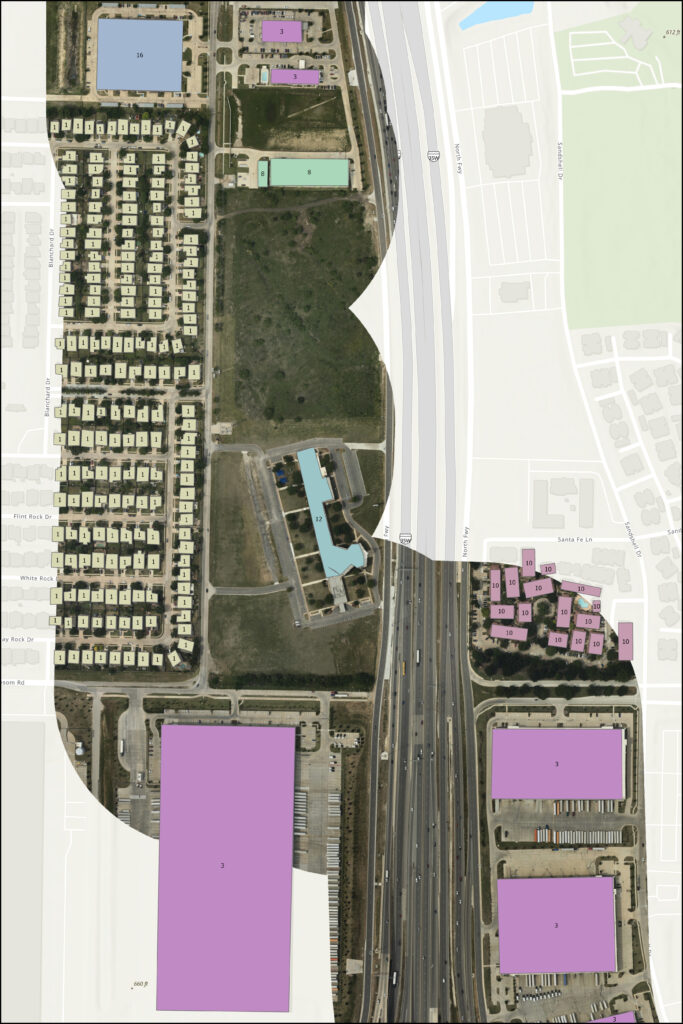
See Prius Intelli’s Structure ID ®
output data in action.
Prius Intelli’s fixed-wing aerial survey and structure digitization identifies, notates, and classifies structures along your pipeline right-of-way (ROW), providing the data needed to easily identify USDOT Class Location, High Consequence Areas (HCA), and Medium Consequence Areas (MCA).
Our turnkey high-resolution imagery and data solution helps you:
Quickly identify trouble spots.
Aerial survey to monitor rights-of-way for encroachment including real estate development trends, construction activity, mobile man camps, and more.
Work smarter, faster with the crews you have.
Free up your manpower to focus on operations, not on continually identifying, counting, and classifying structures, both old and new.
Simplify regulatory compliance.
Produce GIS data sets that can be used to produce verifiable and repeatable results for population density analysis.
Here’s how it works.
RBG Orthophotography
- Aerial photography is imaged along the pipeline centerline.
- High-resolution imagery (4 in) is delivered within 2-4 weeks, weather dependent.
- Imagery is delivered as a streaming service or physical Mosaic.
GIS Data Delivery
- GIS databases are provided that contain digitized polygons for each structure. A code is attributed to each structure to define the structure’s use.
Structure Digitization
- Structure outlines are digitized that fall within a defined buffer of the pipeline.
- Each structure is classified to meet PHMSA population density analysis.
- Structures are delivered as ESRI shapefiles or geodatabases.
How to get started.
1. Submit your pipe centerline file.
2. Approve your custom quote.
3. We fly your AOI.
Imagery is delivered within 2-4 weeks, weather dependent. Delivery time for structure digitization varies depending on the number of ROW miles flown.
Subscription models are available. Contact our sales team for details.


Pipeline Class Location FAQs
Why use aerial imagery to perform Structure Identification?
Monitoring change along the ROW using aerial imagery provides documentation of ROW condition both for regulatory compliance adherence and for the detection of ROW encroachments.
What are Structure Codes?
Each structure is coded to identify the structure’s use. These structure codes are used in GIS Analytical tools to define pipeline segments for Class Location, High Consequence Areas, and Moderate Consequence areas.
Can I submit my existing structures for use in change detection?
Yes. A complete review of existing building footprints can be provided to identify change occurrence.
Can I buy just the imagery?
Absolutely. The RGB imagery is a standalone product. Flown on-demand, it provides invaluable up-to-date insight into Areas of Interest. There is no acreage minimum, and the image file is delivered within two to four weeks, weather dependent. Multiple image resolutions are available. Click here to request a quote.
- Read how Brazos Midstream uses aerial imagery to supercharge its work crews and simplify its class location efforts. DOWNLOAD PROJECT BRIEF
What else can I do with the imagery?
The imagery can be applied to a wide range of operational and planning activities – population density studies, ROW clearing activities, encroachment detection, historical documentation of ROW condition before and after construction activities, and pipeline As Built Alignment Sheets. The imagery can also be used as a background layer in GIS portals.

