

Aerial Photography & GIS Data Smooth the Way for Utility Scale Solar Farm Planning
Aerial Photography & GIS Data Smooth the Way for Utility Scale Solar Farm Planning
Aerial Photography & GIS Data Smooth the Way for Utility Scale Solar Farm Planning
Aerial Photography & GIS Data Smooth the Way for Utility Scale Solar Farm Planning

With any utility-scale greenfield project, everything rises and falls on the solar farm planning stage. Do it right and the project’s success is much more likely. A few mistakes or oversights at this stage could cost millions of dollars and sink the project—or the entire company.
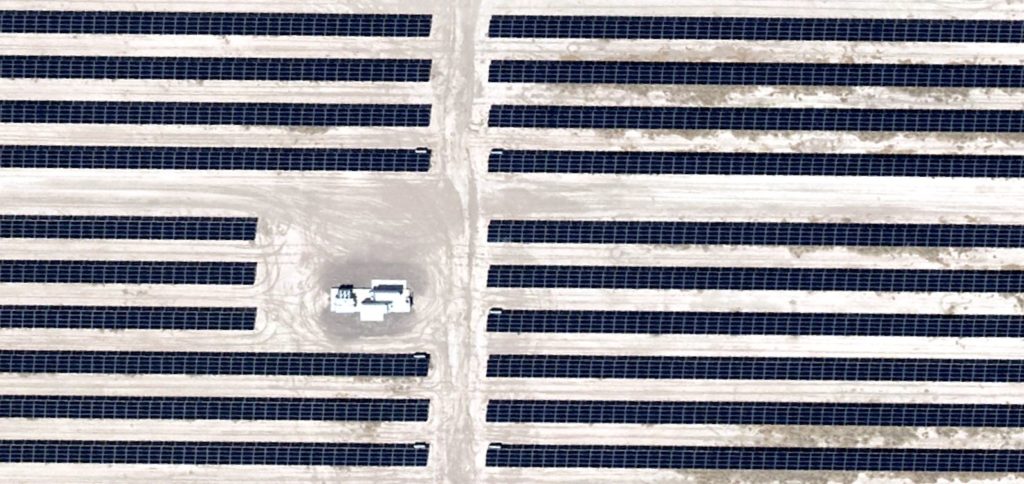
The average size of a utility-scale solar farm ranges from 40 acres to more than 100 acres. Analyzing that much acreage from the ground could take weeks and would require the input of a large number of people. Relying on existing satellite photography can be risky because it may not be up to date, nor be detailed enough to account for all the issues pertinent to permitting and solar farms’ requirements.
Prius Intelli’s aerial data and GIS mapping can efficiently capture detailed information covering vast expanses of territory. After the flyover and a short interval for processing, the information is ready to inform decision makers on whether a site is suitable at all and, if so, how to plan for the overall construction and grid connection process.
Since our aerial imagery is accurate to within a few inches, it can be used to map contours and elevations with extreme precision. Here are some of the requirements that GIS data can inform.
How Flat Is the Land?
Utility-scale solar farms require approximately 4 degrees of slope or less in order to allow panels to maximize the capture of energy as the sun traverses the sky. Single and dual axis panels move up and down and side to side to do this, and must be unobstructed across their whole path.
What is the Vegetation?
Trees are the biggest issue because they block the sun. Any trees present require a decision on the part of the solar farm operator and the landowner. Ground cover vegetation may need to be cleared for panel placement and to accommodate service roads among panels, and for power conversion equipment onsite.
Are There Buildings Onsite?
Depending on location, buildings may need to be removed. Aerial photography makes it easy to pinpoint their locations.
What About Waterways and Drainage?
Large solar farms try to avoid active streams. Runoff can cut ditches and etch slopes across the land. Wetlands can create significant erosion issues, and are usually avoided by solar utilities. Locating these features ahead of time could let the solar company decide to move on or to properly prepare for expenses involved in site preparation.
Where Is the Power Grid?
Getting the generated power to consumers is what makes solar farms work. The greater the distance a farm is from three-phase power and a transmission substation, the more costly it will be to put into service. While there may be outside funding for connectivity, GIS data showing the distance to be covered will let the solar company evaluate the costs involved before moving ahead.
What About Roads and Population?
Access to highways needed for delivery of panels and other equipment as well as ongoing maintenance is another key component. And while there is no safety issue with solar panels that would affect the nearby population, an encroaching subdivision could affect the value of the farm’s lease agreement.
Environmental Concerns
Sometimes environmental permitting can present surprises with endangered species, migratory patterns, and more. We can provide Federal and state overlays for environmental requirements. This was covered in detail in a previous blog—click here for details.
With all this information in one package, it is easy to see the time, money, and effort savings of aerial photography and GIS data. Please contact us to learn more about how we can help you with site selection.


With any utility-scale greenfield project, everything rises and falls on the solar farm planning stage. Do it right and the project’s success is much more likely. A few mistakes or oversights at this stage could cost millions of dollars and sink the project—or the entire company.
The average size of a utility-scale solar farm ranges from 40 acres to more than 100 acres. Analyzing that much acreage from the ground could take weeks and would require the input of a large number of people. Relying on existing satellite photography can be risky because it may not be up to date, nor be detailed enough to account for all the issues pertinent to permitting and solar farms’ requirements.
Prius Intelli’s aerial data and GIS mapping can efficiently capture detailed information covering vast expanses of territory. After the flyover and a short interval for processing, the information is ready to inform decision makers on whether a site is suitable at all and, if so, how to plan for the overall construction and grid connection process.
Since our aerial imagery is accurate to within a few inches, it can be used to map contours and elevations with extreme precision. Here are some of the requirements that GIS data can inform.
How Flat Is the Land?
Utility-scale solar farms require approximately 4 degrees of slope or less in order to allow panels to maximize the capture of energy as the sun traverses the sky. Single and dual axis panels move up and down and side to side to do this, and must be unobstructed across their whole path.
What is the Vegetation?
Trees are the biggest issue because they block the sun. Any trees present require a decision on the part of the solar farm operator and the landowner. Ground cover vegetation may need to be cleared for panel placement and to accommodate service roads among panels, and for power conversion equipment onsite.
Are There Buildings Onsite?
Depending on location, buildings may need to be removed. Aerial photography makes it easy to pinpoint their locations.
What About Waterways and Drainage?
Large solar farms try to avoid active streams. Runoff can cut ditches and etch slopes across the land. Wetlands can create significant erosion issues, and are usually avoided by solar utilities. Locating these features ahead of time could let the solar company decide to move on or to properly prepare for expenses involved in site preparation.
Where Is the Power Grid?
Getting the generated power to consumers is what makes solar farms work. The greater the distance a farm is from three-phase power and a transmission substation, the more costly it will be to put into service. While there may be outside funding for connectivity, GIS data showing the distance to be covered will let the solar company evaluate the costs involved before moving ahead.
What About Roads and Population?
Access to highways needed for delivery of panels and other equipment as well as ongoing maintenance is another key component. And while there is no safety issue with solar panels that would affect the nearby population, an encroaching subdivision could affect the value of the farm’s lease agreement.
Environmental Concerns
Sometimes environmental permitting can present surprises with endangered species, migratory patterns, and more. We can provide Federal and state overlays for environmental requirements. This was covered in detail in a previous blog—click here for details.
With all this information in one package, it is easy to see the time, money, and effort savings of aerial photography and GIS data. Please contact us to learn more about how we can help you with site selection.

