

Remote Sensing Technology in the Oilfield: Exploring Aerial Options
Remote Sensing Technology in the Oilfield: Exploring Aerial Options
Remote Sensing Technology in the Oilfield: Exploring Aerial Options
Remote Sensing Technology in the Oilfield: Exploring Aerial Options

Remote sensing technology gathers information about an object or area from a distance. It involves the use of sensors mounted on drones, aircraft, or satellites to collect electromagnetic radiation emitted or reflected by objects on Earth’s surface. The data collected is transformed into highly actionable information that can pave the way for growth, improvement, and environmental protection.
For the oil and gas industry, utilizing aerial remote sensing solutions is increasingly seen as an operations game-changer. From simple high-resolution orthoimagery to precise vegetation mapping, the data intelligence provided helps solve a variety of challenges – from optimizing pad planning to complying with the PHMSA Mega Rule and USDOT-related regulations.
| Effective Remote Sensing Solutions Deliver Upstream and Midstream Companies: Enhanced accuracy and precision for better decision making. Cost savings in both time and money. Increased collaboration across departments. Simplified regulatory compliance. |
Principles of Remote Sensing
Remote sensing measures the reflected or emitted energy from a surface or object. This energy can be in various wavelengths, including visible light, ultraviolet radiation, and microwave radiation. Remote sensing relies on the interaction of electromagnetic radiation with the surface and the atmosphere. The sensors used in remote sensing collect this energy, which is then processed to produce digital images and/or other information.
Types of Remote Sensors
There are two main types of sensors that collect data remotely: passive and active.
- Passive Sensors: Passive remote sensing utilizes cameras that detect visible, ultraviolet, and/or infrared energy reflected from the Earth’s surface. The sensors do not emit a signal, making them ideal for observing plant health or mapping land use as they do not interfere with natural data.
- Active sensors: Active sensors emit a signal in the form of a laser or radar pulse and measure the energy reflected back to the sensor. These types of sensors are useful in applications that require the measurement of distances, such as terrain mapping. Active sensors are best suited for collecting data in areas where passive sensors may not be able to penetrate due to obstacles such as cloud cover, vegetation, or snow. Active sensors, like radar, can also provide detailed information about the Earth’s surface even in low-light and nighttime conditions.
Types of Aerial Remote Sensing Technology
Aerial remote sensing options include both imagery and direct measurement, which is independent of photography.
IMAGERY (PASSIVE SENSING)
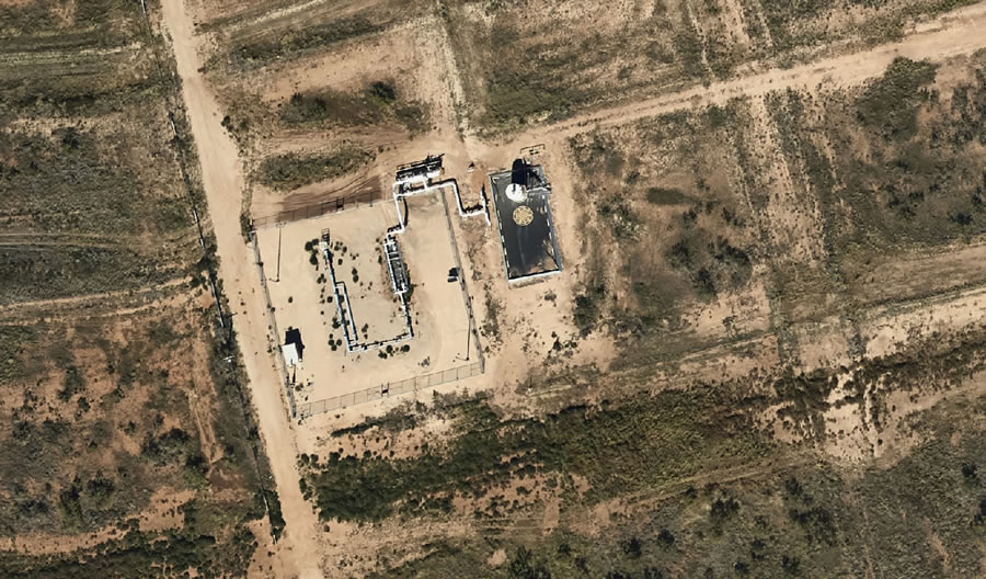
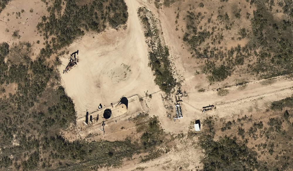
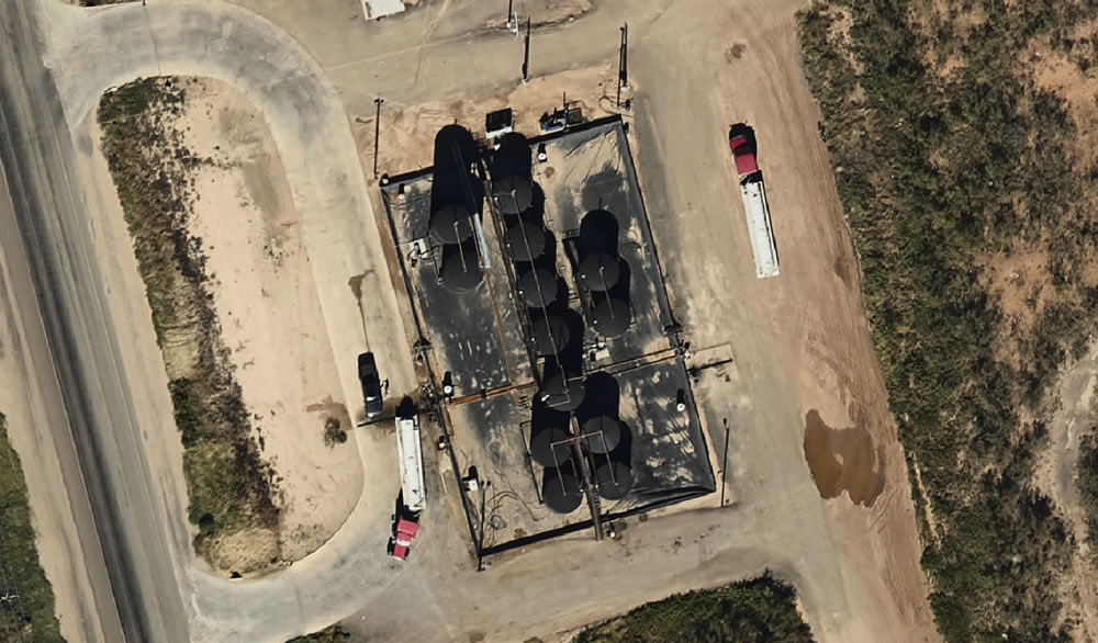
RGB Imagery: RGB imagery captures high-resolution, geospatially accurate orthoimagery by detecting and recording light at different wavelengths in the visible spectrum (red, green, and blue). The orthoimages created through RGB imagery can be used for different applications. For example, they can be used to identify surface features and structures, detect changes in vegetation, and map land use.
RGB imagery can also be processed into photogrammetry. Photogrammetry uses the imagery’s elevation and GIS data to compare individual images, determining angles and how these angles overlap. From there it stitches them together in a mosaic. All this together helps identify ground objects, their location relative to each other, and their height. The result is highly accurate digital surface models (DSM) and digital elevation models (DEM) that provide a detailed picture of an area’s terrain.
| Is photogrammetry a type of remote sensing? No. Photogrammetry utilizes 2D imagery to measure and create 3D models of physical objects, terrain, and other geographic features. The underlying 2D images can be aerial photographs or satellite images captured by remote sensors. Learn more about photogrammetry here. |
4-band Imagery (Multi-Spectral): Similar to RGB, 4-band adds one extra spectral band to capture more information about the environment. The inclusion of Near Infrared (NIR) provides intelligence regarding ground cover types, vegetation health, surface water boundaries, road surface quality, soil erosion levels, and even subtle topographical variations that may otherwise go undetected by more traditional methods.
Thermal Imagery: Thermal imaging works by detecting infrared radiation emitted by objects and turning it into a visible image that displays temperature details. The technology uses special cameras and lenses to detect heat signatures, which are then displayed as various colors on the thermal image. Heat signatures with higher temperatures appear brighter or whiter, while cooler regions appear darker or redder. This temperature data can help detect potential hazards, such as equipment malfunction and leaks, as well as identify areas that require maintenance.
DIRECT MEASUREMENT (ACTIVE SENSING)
LiDAR: LiDAR (Light Detection and Ranging) uses a laser to measure the time it takes for the laser to hit an object and return to the sensor. It provides high-resolution, three-dimensional data called point clouds. It is useful in mapping terrain, detecting changes in elevation and vegetation mapping, and monitoring land cover, including tackling pipeline depth of cover challenges.
RADAR: RADAR (Radio Detection and Ranging) uses radio waves to detect objects and can provide detailed information about the Earth’s surface, including topography, vegetation cover, and moisture levels.
Applications of Fixed-Wing Aerial Remote Sensing Technology in E&P and Midstream
Aerial remote sensing technologies offer the energy industry numerous benefits, including the ability to collect and analyze data over a large geographic area, rapid data collection, consistent data, and the ability to capture data at specific times or on specific schedules to aid in change detection.
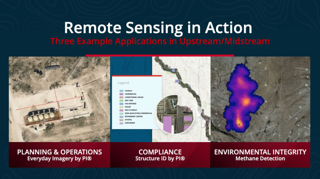
Up to date RGB orthography delivers E&P operators a wide range of efficiencies across all departments. Here are just a few examples of how Prius Intelli’s upstream customers use on-demand imagery in day-to-day planning, operations, and compliance:
- Identify optimal horizontal drilling locations. Assess access options, determine a proposed pad’s proximity to existing infrastructure, and side-step regulatory concerns with smarter pad placement away from problematic areas.
- Plan entire multi-acre pad sites to streamline access, set-up, and operations, especially on complex projects undergoing simultaneous completions and workovers.
- Get quotes faster and reduce vendor-related chaos for quicker equipment deployment on site.
- Calculate exactly how much road base is needed if new roads are required – or if it’s identified that existing roads need repair.
- See specific flow lines and provide regulatory agencies visual proof of mitigation to get them more comfortable with a spill response.
- Reduce change orders by knowing exactly how many (and what type of) fences need to be cut and repaired for infrastructure construction projects that span multiple tracts of land.
For midstream oil and gas, an excellent use of remote sensing is in pipeline management. By analyzing data collected from aerial sources monitoring the pipeline, pipeline owners and operators can quickly identify pipeline damage caused by leaks, corrosion, and other potential risks. This not only makes it much easier to comply with pipeline safety regulations but also prevents environmental disasters.
Here are a few additional examples of how pipeline operators can use data gathered through remote sensing to solve operational and compliance-related challenges.
- Easily address landowner concerns during the route planning process. Learn more.
- Simplify structure identification and class location reporting with high-resolution aerial orthoimagery. Learn more.
- Tackle geohazards and depth of cover regulatory oversight with GIS change detection.
- Manage erosion concerns by utilizing elevation-related data intelligence.
- Speed gas migration control and clean-up efforts with LiDAR. Learn more.
Need help streamlining your PHMSA Mega Rule compliance efforts? Learn about our turnkey Pipeline Population Density Structure Identification solution today.
Remote Sensing Technology Delivers a Clear-Cut Competitive Edge
In this increasingly digitized world, superior data intelligence is a crucial element of success. For the oilfield, remote sensing solutions excel in delivering accuracy of data and precise knowledge of environmental-related events. As such, remote sensing solutions are revolutionizing the way both upstream and midstream companies approach decision-making by providing the information needed to make better informed decisions faster, safer, and with greater confidence.
As technology continues to evolve, fixed-wing remote sensing is sure to be an indispensable tool for energy companies aiming not only to succeed but to excel in the most competitive of landscapes.
Aerial Remote Sensing Technology Options – At A Glance
RGB Orthoimagery
- Operating Principle: Captures data from the visible spectrum to create high-resolution images of the ground surface.
- Data Collected: Identifying surface features and structures, and for detecting changes in vegetation and landform characteristics.
- Equipment Used: aircraft-based sensors or satellites.
- Limitations: The quality of data collected depends on weather conditions like cloud coverage and position of the sun.
Applications of RGB Orthoimagery:
- Monitoring oil pipelines
- Identifying potential environmental hazards
- Maintenance of oil rig and offshore platforms
Multispectral Imagery (4-Band):
- Operating Principle: Multispectral sensors capture data from a range of wavelengths and show the condition of vegetation, moisture content, land cover, and other environmental variables.
- Data Collected: Identifying vegetation and detecting struggling vegetation through reflectance.
- Equipment Used: aircraft-based sensors or satellites.
- Limitations: The quality of data collected depends on weather conditions like cloud coverage and position of the sun.
Applications of Multispectral Imagery:
- Detecting potential environmental damage
- Oil and gas exploration
- Pipeline safety
Thermal Imaging:
- Operating Principle: Thermal sensors detect heat signatures.
- Data Collected: Reveals temperature data and helps identify areas of high or low temperature, including warm equipment areas caused by reduced insulation, chemicals or leakage, or cold areas due to chiller issues.
- Equipment Used: Aircraft-based sensors or satellites.
- Limitations: The sensor is extremely sensitive to weather conditions. For optimal results, measurements should be taken in cooler temperatures, in low wind conditions, and at night so that there is no solar gain on the object(s) being studied.
Applications of Thermal Imagery:
- Preventive maintenance – detecting potential equipment failure or damage.
- Pipeline leak detection and location.
- Detection of insulation value changes in pipelines.
- Storage tank level detection.
- Environmental monitoring.
LiDAR:
- Operating Principle: LiDAR sensors bounce laser beams and measure the returning time to provide information about ground terrain and its structure.
- Data Collected: Create high-resolution 3D maps of the ground and objects.
- Equipment Used: aerial or ground positioning LiDAR systems.
- Limitations: Large datasets can present inefficiencies during processing procedures.
Applications of LiDAR:
- Topographical mapping for oil and gas exploration
- Oil rig and platform infrastructure monitoring
- Offshore oil spill detection and response
RADAR
- Operating Principle: RADAR sensors transmit radio waves towards the Earth’s surface and measure the energy that is reflected back to create detailed measurements of distance and elevation.
- Data Collected: Captures information about the Earth’s surface elevation and the characteristics of objects, including size, shape, and material composition, within the signal range.
- Equipment Used: Airborne, ground-based, or satellite-mounted RADAR systems.
- Limitations: Radar requires large amounts of energy to transmit waves and process large datasets. Data processing can be complex and time-consuming. The accuracy of the data collected may be affected by atmospheric conditions such as precipitation, wind, and temperature variations.
Applications of RADAR:
- Weather forecasting and monitoring for severe weather patterns including tornadoes, hurricanes, and thunderstorms.
- Mapping and monitoring of environmental features such as forest growth, wetlands, and oceanography.
- Military surveillance and detection systems (including missile and aircraft detection)
- Air traffic control (including collision avoidance systems) and airport safety.


Remote sensing technology gathers information about an object or area from a distance. It involves the use of sensors mounted on drones, aircraft, or satellites to collect electromagnetic radiation emitted or reflected by objects on Earth’s surface. The data collected is transformed into highly actionable information that can pave the way for growth, improvement, and environmental protection.
For the oil and gas industry, utilizing aerial remote sensing solutions is increasingly seen as an operations game-changer. From simple high-resolution orthoimagery to precise vegetation mapping, the data intelligence provided helps solve a variety of challenges – from optimizing pad planning to complying with the PHMSA Mega Rule and USDOT-related regulations.
| Effective Remote Sensing Solutions Deliver Upstream and Midstream Companies: Enhanced accuracy and precision for better decision making. Cost savings in both time and money. Increased collaboration across departments. Simplified regulatory compliance. |
Principles of Remote Sensing
Remote sensing measures the reflected or emitted energy from a surface or object. This energy can be in various wavelengths, including visible light, ultraviolet radiation, and microwave radiation. Remote sensing relies on the interaction of electromagnetic radiation with the surface and the atmosphere. The sensors used in remote sensing collect this energy, which is then processed to produce digital images and/or other information.
Types of Remote Sensors
There are two main types of sensors that collect data remotely: passive and active.
- Passive Sensors: Passive remote sensing utilizes cameras that detect visible, ultraviolet, and/or infrared energy reflected from the Earth’s surface. The sensors do not emit a signal, making them ideal for observing plant health or mapping land use as they do not interfere with natural data.
- Active sensors: Active sensors emit a signal in the form of a laser or radar pulse and measure the energy reflected back to the sensor. These types of sensors are useful in applications that require the measurement of distances, such as terrain mapping. Active sensors are best suited for collecting data in areas where passive sensors may not be able to penetrate due to obstacles such as cloud cover, vegetation, or snow. Active sensors, like radar, can also provide detailed information about the Earth’s surface even in low-light and nighttime conditions.
Types of Aerial Remote Sensing Technology
Aerial remote sensing options include both imagery and direct measurement, which is independent of photography.
IMAGERY (PASSIVE SENSING)
RGB Imagery: RGB imagery captures high-resolution, geospatially accurate orthoimagery by detecting and recording light at different wavelengths in the visible spectrum (red, green, and blue). The orthoimages created through RGB imagery can be used for different applications. For example, they can be used to identify surface features and structures, detect changes in vegetation, and map land use.
RGB imagery can also be processed into photogrammetry. Photogrammetry uses the imagery’s elevation and GIS data to compare individual images, determining angles and how these angles overlap. From there it stitches them together in a mosaic. All this together helps identify ground objects, their location relative to each other, and their height. The result is highly accurate digital surface models (DSM) and digital elevation models (DEM) that provide a detailed picture of an area’s terrain.
| Is photogrammetry a type of remote sensing? No. Photogrammetry utilizes 2D imagery to measure and create 3D models of physical objects, terrain, and other geographic features. The underlying 2D images can be aerial photographs or satellite images captured by remote sensors. Learn more about photogrammetry here. |
4-band Imagery (Multi-Spectral): Similar to RGB, 4-band adds one extra spectral band to capture more information about the environment. The inclusion of Near Infrared (NIR) provides intelligence regarding ground cover types, vegetation health, surface water boundaries, road surface quality, soil erosion levels, and even subtle topographical variations that may otherwise go undetected by more traditional methods.
Thermal Imagery: Thermal imaging works by detecting infrared radiation emitted by objects and turning it into a visible image that displays temperature details. The technology uses special cameras and lenses to detect heat signatures, which are then displayed as various colors on the thermal image. Heat signatures with higher temperatures appear brighter or whiter, while cooler regions appear darker or redder. This temperature data can help detect potential hazards, such as equipment malfunction and leaks, as well as identify areas that require maintenance.
DIRECT MEASUREMENT (ACTIVE SENSING)
LiDAR: LiDAR (Light Detection and Ranging) uses a laser to measure the time it takes for the laser to hit an object and return to the sensor. It provides high-resolution, three-dimensional data called point clouds. It is useful in mapping terrain, detecting changes in elevation and vegetation mapping, and monitoring land cover, including tackling pipeline depth of cover challenges.
RADAR: RADAR (Radio Detection and Ranging) uses radio waves to detect objects and can provide detailed information about the Earth’s surface, including topography, vegetation cover, and moisture levels.
Applications of Fixed-Wing Aerial Remote Sensing Technology in E&P and Midstream
Aerial remote sensing technologies offer the energy industry numerous benefits, including the ability to collect and analyze data over a large geographic area, rapid data collection, consistent data, and the ability to capture data at specific times or on specific schedules to aid in change detection.
Up to date RGB orthography delivers E&P operators a wide range of efficiencies across all departments. Here are just a few examples of how Prius Intelli’s upstream customers use on-demand imagery in day-to-day planning, operations, and compliance:
- Identify optimal horizontal drilling locations. Assess access options, determine a proposed pad’s proximity to existing infrastructure, and side-step regulatory concerns with smarter pad placement away from problematic areas.
- Plan entire multi-acre pad sites to streamline access, set-up, and operations, especially on complex projects undergoing simultaneous completions and workovers.
- Get quotes faster and reduce vendor-related chaos for quicker equipment deployment on site.
- Calculate exactly how much road base is needed if new roads are required – or if it’s identified that existing roads need repair.
- See specific flow lines and provide regulatory agencies visual proof of mitigation to get them more comfortable with a spill response.
- Reduce change orders by knowing exactly how many (and what type of) fences need to be cut and repaired for infrastructure construction projects that span multiple tracts of land.
For midstream oil and gas, an excellent use of remote sensing is in pipeline management. By analyzing data collected from aerial sources monitoring the pipeline, pipeline owners and operators can quickly identify pipeline damage caused by leaks, corrosion, and other potential risks. This not only makes it much easier to comply with pipeline safety regulations but also prevents environmental disasters.
Here are a few additional examples of how pipeline operators can use data gathered through remote sensing to solve operational and compliance-related challenges.
- Easily address landowner concerns during the route planning process. Learn more.
- Simplify structure identification and class location reporting with high-resolution aerial orthoimagery. Learn more.
- Tackle geohazards and depth of cover regulatory oversight with GIS change detection.
- Manage erosion concerns by utilizing elevation-related data intelligence.
- Speed gas migration control and clean-up efforts with LiDAR. Learn more.
Need help streamlining your PHMSA Mega Rule compliance efforts? Learn about our turnkey Pipeline Population Density Structure Identification solution today.
Remote Sensing Technology Delivers a Clear-Cut Competitive Edge
In this increasingly digitized world, superior data intelligence is a crucial element of success. For the oilfield, remote sensing solutions excel in delivering accuracy of data and precise knowledge of environmental-related events. As such, remote sensing solutions are revolutionizing the way both upstream and midstream companies approach decision-making by providing the information needed to make better informed decisions faster, safer, and with greater confidence.
As technology continues to evolve, fixed-wing remote sensing is sure to be an indispensable tool for energy companies aiming not only to succeed but to excel in the most competitive of landscapes.
Aerial Remote Sensing Technology Options – At A Glance
RGB Orthoimagery
- Operating Principle: Captures data from the visible spectrum to create high-resolution images of the ground surface.
- Data Collected: Identifying surface features and structures, and for detecting changes in vegetation and landform characteristics.
- Equipment Used: aircraft-based sensors or satellites.
- Limitations: The quality of data collected depends on weather conditions like cloud coverage and position of the sun.
Applications of RGB Orthoimagery:
- Monitoring oil pipelines
- Identifying potential environmental hazards
- Maintenance of oil rig and offshore platforms
Multispectral Imagery (4-Band):
- Operating Principle: Multispectral sensors capture data from a range of wavelengths and show the condition of vegetation, moisture content, land cover, and other environmental variables.
- Data Collected: Identifying vegetation and detecting struggling vegetation through reflectance.
- Equipment Used: aircraft-based sensors or satellites.
- Limitations: The quality of data collected depends on weather conditions like cloud coverage and position of the sun.
Applications of Multispectral Imagery:
- Detecting potential environmental damage
- Oil and gas exploration
- Pipeline safety
Thermal Imaging:
- Operating Principle: Thermal sensors detect heat signatures.
- Data Collected: Reveals temperature data and helps identify areas of high or low temperature, including warm equipment areas caused by reduced insulation, chemicals or leakage, or cold areas due to chiller issues.
- Equipment Used: Aircraft-based sensors or satellites.
- Limitations: The sensor is extremely sensitive to weather conditions. For optimal results, measurements should be taken in cooler temperatures, in low wind conditions, and at night so that there is no solar gain on the object(s) being studied.
Applications of Thermal Imagery:
- Preventive maintenance – detecting potential equipment failure or damage.
- Pipeline leak detection and location.
- Detection of insulation value changes in pipelines.
- Storage tank level detection.
- Environmental monitoring.
LiDAR:
- Operating Principle: LiDAR sensors bounce laser beams and measure the returning time to provide information about ground terrain and its structure.
- Data Collected: Create high-resolution 3D maps of the ground and objects.
- Equipment Used: aerial or ground positioning LiDAR systems.
- Limitations: Large datasets can present inefficiencies during processing procedures.
Applications of LiDAR:
- Topographical mapping for oil and gas exploration
- Oil rig and platform infrastructure monitoring
- Offshore oil spill detection and response
RADAR
- Operating Principle: RADAR sensors transmit radio waves towards the Earth’s surface and measure the energy that is reflected back to create detailed measurements of distance and elevation.
- Data Collected: Captures information about the Earth’s surface elevation and the characteristics of objects, including size, shape, and material composition, within the signal range.
- Equipment Used: Airborne, ground-based, or satellite-mounted RADAR systems.
- Limitations: Radar requires large amounts of energy to transmit waves and process large datasets. Data processing can be complex and time-consuming. The accuracy of the data collected may be affected by atmospheric conditions such as precipitation, wind, and temperature variations.
Applications of RADAR:
- Weather forecasting and monitoring for severe weather patterns including tornadoes, hurricanes, and thunderstorms.
- Mapping and monitoring of environmental features such as forest growth, wetlands, and oceanography.
- Military surveillance and detection systems (including missile and aircraft detection)
- Air traffic control (including collision avoidance systems) and airport safety.

