

LiDAR Speeds Gas Migration Control Compared to Ground Inspection
LiDAR Speeds Gas Migration Control Compared to Ground Inspection
LiDAR Speeds Gas Migration Control Compared to Ground Inspection
LiDAR Speeds Gas Migration Control Compared to Ground Inspection

Oil and gas pipelines deliver energy from well to refinery to gas tank (and a thousand other uses) across the United States. Everyone from environmental activists to oil company executives wants that product to stay inside the pipeline from start to finish. But sometimes something happens and there’s a leak. Tracking and containing the leaking substance is called gas migration control. Aerial photography with LiDAR helps speed repair and cleanup, minimizing damage to the environment and danger to people.
Because of its wide application for clients, Prius Intelli has recently added LiDAR to its service list. Read on to see some of its many benefits for the midstream sector, which is just one of the areas in which it is vital.
First, a quick definition of LiDAR. It stands for Light Detection and Ranging. A LiDAR system uses laser impulses to measure variable distances from the earth. These variable distances enable precise elevation data, generating 3-D images of the land.
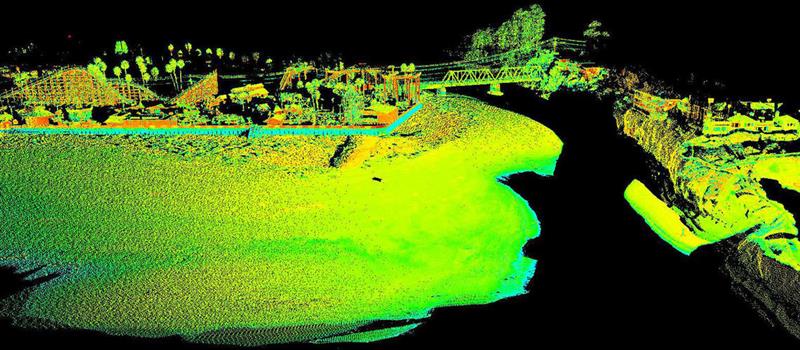
LiDAR stands for Light Detection and Ranging. A LiDAR system uses laser impulses to measure variable distances from the earth. These variable distances enable precise elevation data, generating 3-D images of the land.
Why Aerial LiDAR Photography Helps Monitor Gas Migration
When a leak happens, there are two priorities: stopping the flow from the pipeline and protecting the environment and nearby people. That involves preventing what’s already leaked out from reaching the watershed, including nearby lakes, oceans, streams or rivers. This is especially vital near coastal regions where recovery becomes much more difficult.
Because LiDAR uses laser light, it can penetrate foliage layers where conventional photography can’t. That means it can provide accurate and detailed slope data even on land covered with trees or thick shrubbery.
This allows the creation of a precisely located GIS contours and slope modeling that reveals the likely path of the migration of oil and gas leaking from the pipeline. Software can remove all surface structures, along with vegetation, so planners can see just the ground, giving them a clear view of primary migration, showing clearly where mitigation efforts need to focus.
You might ask, “Don’t you have to have crews on the ground anyway to control the migration of oil and gas? Why not just let them look for it while they’re there?” Yes, only on-site people can do the cleanup and the pipeline repair. But oil and gas migration can happen fast, and over a larger area than may be apparent from the ground. Aerial LiDAR can quickly cover miles and miles, which tells the cleanup crews exactly where to start and where to anticipate its direction of flow.
How does LiDAR help you know you’ve got a leak?
Oil and gasoline or other refined liquids are the easiest to monitor. Oil is black, and gasoline and other liquids appear as sheen on top of water. When natural gas leaks under water, it creates bubbles as it rises to the surface. On land, it will quickly kill nearby surface vegetation.
LiDAR helps you spot these trouble spots from your desktop.
Seeing these indications is important because, in pipelines, natural gas is invisible and odorless making it hard to detect in person. The rotten-egg-smelling mercaptan isn’t injected until it heads out locally to homes and businesses. Unfortunately, natural gas is just as flammable in the pipeline as it is at home, just in larger quantities. Locating and repairing a leak is even more important in that pipeline.
What causes a pipeline leak?
There are two possible forces: humans and nature. Nature can be a factor through earthquakes, mudslides, and washouts from flooding. Areas in the mountain west and in Appalachia in particular are subject to landslides, which can crack or rupture pipelines.
In these places, LiDAR taken every 6-12 months can detect land shifts or erosion before they cause an issue. LiDAR elevation data can spot even a few inches of movement or topsoil erosion. While a pipeline can probably withstand that much shift, it can’t continue to move without creating issues. In that case, midstream companies need to act sooner rather than later.
Humans most often cause a rupture with machinery. Sometimes it can come from digging around the line to do preventive maintenance. Other times it could be someone running a water line, building a road or doing other dirt work, if they have failed to locate the existing line before starting work.
In Brief
Here’s a quick summary of the benefits of aerial LiDAR in controlling the migration of oil and gas.
- Covers more territory quickly
- Gives contours and slope modeling to predict flow patterns toward lakes and streams
- Gives the scope of the entire issue, prioritizing crew assignments
- LiDAR “sees” through vegetation to give accurately detailed slope information
- Software can remove buildings and vegetation to reveal ground slope
- More detailed and timely than satellite photography
To learn more about how Prius Intelli’s LiDAR services can help better monitor your AOIs, contact us today.


Oil and gas pipelines deliver energy from well to refinery to gas tank (and a thousand other uses) across the United States. Everyone from environmental activists to oil company executives wants that product to stay inside the pipeline from start to finish. But sometimes something happens and there’s a leak. Tracking and containing the leaking substance is called gas migration control. Aerial photography with LiDAR helps speed repair and cleanup, minimizing damage to the environment and danger to people.
Because of its wide application for clients, Prius Intelli has recently added LiDAR to its service list. Read on to see some of its many benefits for the midstream sector, which is just one of the areas in which it is vital.
First, a quick definition of LiDAR. It stands for Light Detection and Ranging. A LiDAR system uses laser impulses to measure variable distances from the earth. These variable distances enable precise elevation data, generating 3-D images of the land.
LiDAR stands for Light Detection and Ranging. A LiDAR system uses laser impulses to measure variable distances from the earth. These variable distances enable precise elevation data, generating 3-D images of the land.
Why Aerial LiDAR Photography Helps Monitor Gas Migration
When a leak happens, there are two priorities: stopping the flow from the pipeline and protecting the environment and nearby people. That involves preventing what’s already leaked out from reaching the watershed, including nearby lakes, oceans, streams or rivers. This is especially vital near coastal regions where recovery becomes much more difficult.
Because LiDAR uses laser light, it can penetrate foliage layers where conventional photography can’t. That means it can provide accurate and detailed slope data even on land covered with trees or thick shrubbery.
This allows the creation of a precisely located GIS contours and slope modeling that reveals the likely path of the migration of oil and gas leaking from the pipeline. Software can remove all surface structures, along with vegetation, so planners can see just the ground, giving them a clear view of primary migration, showing clearly where mitigation efforts need to focus.
You might ask, “Don’t you have to have crews on the ground anyway to control the migration of oil and gas? Why not just let them look for it while they’re there?” Yes, only on-site people can do the cleanup and the pipeline repair. But oil and gas migration can happen fast, and over a larger area than may be apparent from the ground. Aerial LiDAR can quickly cover miles and miles, which tells the cleanup crews exactly where to start and where to anticipate its direction of flow.
How does LiDAR help you know you’ve got a leak?
Oil and gasoline or other refined liquids are the easiest to monitor. Oil is black, and gasoline and other liquids appear as sheen on top of water. When natural gas leaks under water, it creates bubbles as it rises to the surface. On land, it will quickly kill nearby surface vegetation.
LiDAR helps you spot these trouble spots from your desktop.
Seeing these indications is important because, in pipelines, natural gas is invisible and odorless making it hard to detect in person. The rotten-egg-smelling mercaptan isn’t injected until it heads out locally to homes and businesses. Unfortunately, natural gas is just as flammable in the pipeline as it is at home, just in larger quantities. Locating and repairing a leak is even more important in that pipeline.
What causes a pipeline leak?
There are two possible forces: humans and nature. Nature can be a factor through earthquakes, mudslides, and washouts from flooding. Areas in the mountain west and in Appalachia in particular are subject to landslides, which can crack or rupture pipelines.
In these places, LiDAR taken every 6-12 months can detect land shifts or erosion before they cause an issue. LiDAR elevation data can spot even a few inches of movement or topsoil erosion. While a pipeline can probably withstand that much shift, it can’t continue to move without creating issues. In that case, midstream companies need to act sooner rather than later.
Humans most often cause a rupture with machinery. Sometimes it can come from digging around the line to do preventive maintenance. Other times it could be someone running a water line, building a road or doing other dirt work, if they have failed to locate the existing line before starting work.
In Brief
Here’s a quick summary of the benefits of aerial LiDAR in controlling the migration of oil and gas.
- Covers more territory quickly
- Gives contours and slope modeling to predict flow patterns toward lakes and streams
- Gives the scope of the entire issue, prioritizing crew assignments
- LiDAR “sees” through vegetation to give accurately detailed slope information
- Software can remove buildings and vegetation to reveal ground slope
- More detailed and timely than satellite photography
To learn more about how Prius Intelli’s LiDAR services can help better monitor your AOIs, contact us today.

