

How Up to Date is Google Earth? Do You Really Know?
How Up to Date is Google Earth? Do You Really Know?
How Up to Date is Google Earth? Do You Really Know?
How Up to Date is Google Earth? Do You Really Know?

Hint: Updates Are Sporadic. Prius Intelli is the Google Earth Alternative for Current Data
Have you ever looked at your neighborhood on Google Earth, and found it showing that the car you sold two years ago is parked right there in your driveway? That makes you wonder, “How up to date is Google Earth?” The answer is it could be three years old or more, depending on the area.
Google Earth Alternative
Google reports that it is updated monthly and that’s true. But they only do certain sections each month, and it takes about three years to update all of it. With the tens of millions of photos required to cover the earth, that’s understandable, but it doesn’t help you if the photos your site planning requires are on the back end of the cycle – or if part of the area is current and part isn’t. Your next question then will be “What is a good alternative to Google Earth?”
Types of Projects Where Prius Intelli Surpasses Web-Based Map Views
Let’s start by examining how you’re using aerial data and why satellites don’t get you there.
Here are some of the top business uses for aerial data:
- Site planning
- Right of way (ROW) planning for pipelines, power lines, roads, other infrastructure
- Change detection for construction or other projects
- Vegetation management
- Elevation (contour lines, stream flow, catchments)
Developers are finding new uses for aerial data every day, but these are among the most widely used. Next, we’ll examine why satellite data is not enough for what these jobs require.
Top 5 Attributes to Look for in a Google Earth Alternative
Whatever project you need your aerial imagery to inform, the imagery must excel in five unique ways. We’ll look at each of those individually and explain how Prius Intelli’s on-demand imagery, captured to your specifications, is better for you than satellite images.
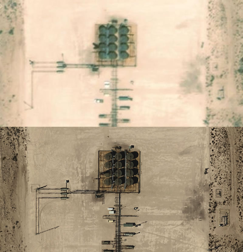
#1: Resolution. For site planning, you’ll want to accurately identify what you’re seeing. You may be looking for objects like fences, vegetation, roadways, waterways and more. You’ll also need elevation data if you’re planning for drainage or runoff. Satellite data usually does not provide finer detail. If you’re looking for smaller features, they may not be recognizable from Google Earth. And satellites may provide some elevation data, but it may be lower resolution than is helpful.
Prius Intelli aerial imagery zooms in from 15 centimeters down to 2.5 centimeters—you can identify many types of encroaching vegetation, smaller features, and some scattered debris. We give you a much clearer view of what is down there, up close.
#2: Visibility. Because satellite views originate from stationary earth orbit, they can be blocked or at least hindered by miles of clouds and dust. Even Superman would have a hard time finding roads, rivers, or pipeline routes through all that.
Prius Intelli, on the other hand, flies directly overhead, scouring the surface for everything you have to see. And if it happens to be raining at the wrong time, they can reschedule. They gather your data where, when, and how you need it.
#3: Timeliness. We’ve discussed this some above, so here are some more specifics. Free satellite views like Google Earth are currently not useful for monitoring site changes or construction progress. If management people at the home office 500 miles away need detailed updates on site construction, infrastructure development, flood or storm damage or anything else that can change more often than at three-year intervals—you need a Google Earth alternative.
You can schedule Prius Intelli to take aerial photographs on your schedule to monitor progress and to protect your assets. Regular data collection also helps on-ground personnel organize the worksite. They can place equipment and machinery where they’re needed and improve work traffic flow patterns for safety and efficiency.
#4: Accuracy. With any kind of aerial imagery, the raw photo deals with at least some distortion as you get further from the center of the photo. Since most imagery involves a mosaic of dozens of connected photos, if that distortion were not corrected it would be difficult to accurately gauge distances between objects.
Orthorectification removes the distortions. Both Prius Intelli and Google Earth do this. That assures you that the photos show you exactly what’s there, where it is, and its relative size.
Plus, using GIS data, Prius Intelli can inform property lines and other data. While it’s still not quite survey grade—boots on the ground are required for an actual survey—this data is useful for planning right of way (ROW) and other location-based work.
#5. Completeness/The Human Touch. With satellite imagery, if you’re looking for image processing like elevation data or orthoimagery, you may have to contract with someone to get you the detail for your project. As a vertically integrated company we get you everything, in-house.
Our imagery is high-resolution and highly accurate, and so is the elevation data we derive from it. Instead of collecting it in bulk and reselling like some satellites, your whole project, start to finish, gets our full attention. You’ll get exactly everything you require and nothing less.
You can rely on getting exactly what you’re looking for because, with Prius Intelli, you’re conversing with real people. If you have questions about the kind of data your project requires, we can help. Did your needs change during a construction monitoring project? Want to reschedule a change detection follow-up because of supply chain delays? We can do that because we care about you and your project.
The Kind of Data You Can’t Get from Satellite Views
How will you process the imagery when it comes to you? Larger companies may already have imagery systems in place. But if you’re smaller, or new to adopting aerial imagery, you may need a simple format. At Prius Intelli, we work with you where you’re at today. So, we can provide just about any kind of image format you require.
Types include .tif/.shp, WMS/WMTS, tiled .kml, XYZ tiles, and slippy map. Here’s more detail on each of those:
- .tif These are the actual images, sometimes used by companies that want to host the imagery on their own servers.
- .shp Shapefile. The actual elevation files, but for polygons and lines like stream networks, contour lines, and drainage basins. For those with their own GIS systems.
- WMS/WMTS This refers to Web Map Service and Web Map Tile Service, for use with someone’s existing GIS or CAD system.
- Tiled .kml- Google Earth Files they can be streamed into Google Earth.
- XYZ Tiles Also similar to both WMS and .kml, we usually host these on our server and stream them to a client’s GIS or CAD system. They can be loaded into slippy maps (next item)
- Slippy Map Slippy maps are online web browser-based maps, delivered to clients by a web link. Simply click
ingon the link and see all your data. You can pan in any direction, zoom in or out and apply various layers over the imagery. You can get both imagery and elevation data this way. This is great for clients who don’t already have GIS or CAD experience.
Why It’s Important
It’s the difference between off-the-shelf and custom, as you ordered it. Current, accurate and clear imagery is surprisingly affordable and is readily available through Prius Intelli. It answers your questions, informs your planning, and makes your operation more efficient. And you’re working with real people who are fully committed to listening to you. We are ready to deliver.
For aerial data, Prius Intelli is by far the right solution and viable Google Earth alternative.


Hint: Updates Are Sporadic. Prius Intelli is the Google Earth Alternative for Current Data
Have you ever looked at your neighborhood on Google Earth, and found it showing that the car you sold two years ago is parked right there in your driveway? That makes you wonder, “How up to date is Google Earth?” The answer is it could be three years old or more, depending on the area.
Google Earth Alternative
Google reports that it is updated monthly and that’s true. But they only do certain sections each month, and it takes about three years to update all of it. With the tens of millions of photos required to cover the earth, that’s understandable, but it doesn’t help you if the photos your site planning requires are on the back end of the cycle – or if part of the area is current and part isn’t. Your next question then will be “What is a good alternative to Google Earth?”
Types of Projects Where Prius Intelli Surpasses Web-Based Map Views
Let’s start by examining how you’re using aerial data and why satellites don’t get you there.
Here are some of the top business uses for aerial data:
- Site planning
- Right of way (ROW) planning for pipelines, power lines, roads, other infrastructure
- Change detection for construction or other projects
- Vegetation management
- Elevation (contour lines, stream flow, catchments)
Developers are finding new uses for aerial data every day, but these are among the most widely used. Next, we’ll examine why satellite data is not enough for what these jobs require.
Top 5 Attributes to Look for in a Google Earth Alternative
Whatever project you need your aerial imagery to inform, the imagery must excel in five unique ways. We’ll look at each of those individually and explain how Prius Intelli’s on-demand imagery, captured to your specifications, is better for you than satellite images.
#1: Resolution. For site planning, you’ll want to accurately identify what you’re seeing. You may be looking for objects like fences, vegetation, roadways, waterways and more. You’ll also need elevation data if you’re planning for drainage or runoff. Satellite data usually does not provide finer detail. If you’re looking for smaller features, they may not be recognizable from Google Earth. And satellites may provide some elevation data, but it may be lower resolution than is helpful.
Prius Intelli aerial imagery zooms in from 15 centimeters down to 2.5 centimeters—you can identify many types of encroaching vegetation, smaller features, and some scattered debris. We give you a much clearer view of what is down there, up close.
#2: Visibility. Because satellite views originate from stationary earth orbit, they can be blocked or at least hindered by miles of clouds and dust. Even Superman would have a hard time finding roads, rivers, or pipeline routes through all that.
Prius Intelli, on the other hand, flies directly overhead, scouring the surface for everything you have to see. And if it happens to be raining at the wrong time, they can reschedule. They gather your data where, when, and how you need it.
#3: Timeliness. We’ve discussed this some above, so here are some more specifics. Free satellite views like Google Earth are currently not useful for monitoring site changes or construction progress. If management people at the home office 500 miles away need detailed updates on site construction, infrastructure development, flood or storm damage or anything else that can change more often than at three-year intervals—you need a Google Earth alternative.
You can schedule Prius Intelli to take aerial photographs on your schedule to monitor progress and to protect your assets. Regular data collection also helps on-ground personnel organize the worksite. They can place equipment and machinery where they’re needed and improve work traffic flow patterns for safety and efficiency.
#4: Accuracy. With any kind of aerial imagery, the raw photo deals with at least some distortion as you get further from the center of the photo. Since most imagery involves a mosaic of dozens of connected photos, if that distortion were not corrected it would be difficult to accurately gauge distances between objects.
Orthorectification removes the distortions. Both Prius Intelli and Google Earth do this. That assures you that the photos show you exactly what’s there, where it is, and its relative size.
Plus, using GIS data, Prius Intelli can inform property lines and other data. While it’s still not quite survey grade—boots on the ground are required for an actual survey—this data is useful for planning right of way (ROW) and other location-based work.
#5. Completeness/The Human Touch. With satellite imagery, if you’re looking for image processing like elevation data or orthoimagery, you may have to contract with someone to get you the detail for your project. As a vertically integrated company we get you everything, in-house.
Our imagery is high-resolution and highly accurate, and so is the elevation data we derive from it. Instead of collecting it in bulk and reselling like some satellites, your whole project, start to finish, gets our full attention. You’ll get exactly everything you require and nothing less.
You can rely on getting exactly what you’re looking for because, with Prius Intelli, you’re conversing with real people. If you have questions about the kind of data your project requires, we can help. Did your needs change during a construction monitoring project? Want to reschedule a change detection follow-up because of supply chain delays? We can do that because we care about you and your project.
The Kind of Data You Can’t Get from Satellite Views
How will you process the imagery when it comes to you? Larger companies may already have imagery systems in place. But if you’re smaller, or new to adopting aerial imagery, you may need a simple format. At Prius Intelli, we work with you where you’re at today. So, we can provide just about any kind of image format you require.
Types include .tif/.shp, WMS/WMTS, tiled .kml, XYZ tiles, and slippy map. Here’s more detail on each of those:
- .tif These are the actual images, sometimes used by companies that want to host the imagery on their own servers.
- .shp Shapefile. The actual elevation files, but for polygons and lines like stream networks, contour lines, and drainage basins. For those with their own GIS systems.
- WMS/WMTS This refers to Web Map Service and Web Map Tile Service, for use with someone’s existing GIS or CAD system.
- Tiled .kml- Google Earth Files they can be streamed into Google Earth.
- XYZ Tiles Also similar to both WMS and .kml, we usually host these on our server and stream them to a client’s GIS or CAD system. They can be loaded into slippy maps (next item)
- Slippy Map Slippy maps are online web browser-based maps, delivered to clients by a web link. Simply click
ingon the link and see all your data. You can pan in any direction, zoom in or out and apply various layers over the imagery. You can get both imagery and elevation data this way. This is great for clients who don’t already have GIS or CAD experience.
Why It’s Important
It’s the difference between off-the-shelf and custom, as you ordered it. Current, accurate and clear imagery is surprisingly affordable and is readily available through Prius Intelli. It answers your questions, informs your planning, and makes your operation more efficient. And you’re working with real people who are fully committed to listening to you. We are ready to deliver.
For aerial data, Prius Intelli is by far the right solution and viable Google Earth alternative.

