

Exploring the Differences Between an Orthophoto and an Aerial Photo
Exploring the Differences Between an Orthophoto and an Aerial Photo
Exploring the Differences Between an Orthophoto and an Aerial Photo
Exploring the Differences Between an Orthophoto and an Aerial Photo

On a cursory glance, an orthophoto and an aerial photo may look the same. But there is a huge difference between the two. Thus, for professionals doing site planning, pipeline or utility routing, a simple aerial photo won’t do. For that, an orthophoto is needed.
Why? Read on.
The Shortcoming of Just an Aerial Photo
You’ve probably seen a picture of a long-nosed dog’s face jammed right up in the camera lens. That nose looks bigger than the dog’s whole body, because cameras distort objects based on how close they are to the camera. The closer something is (the nose), the bigger it looks.
To a lesser (and less amusing) extent, a simple aerial photo also contains distortions. Images right under the camera are also a bit larger than those farther away. Distance can create other distortions, especially on photos of wider areas, which are taken from higher elevations.
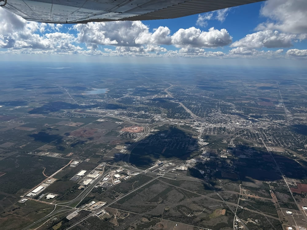
Here’s what that means to you: if you need to know details—like exact structure locations in order to route roads, pipelines or power lines around them, you’ll need every item in the photo to be to the same scale. That accuracy comes into play with planning pipeline supplies and expenses; with placing buildings on a facility site; with working around lakes and rivers; with evaluating the amounts of dirt moving or leveling that will be required; and much more.
An orthophoto is processed to remove all its geometric distortions. It makes sure everything in the photo, from the very center to the outermost edges, is to the same scale.
What’s an Orthophoto? Why Is It Better?
An orthophoto is processed to remove all its geometric distortions. It makes sure everything in the photo, from the very center to the outermost edges, is to the same scale. Now you can accurately measure, plan and cost-estimate new installations. With a series of photos taken over time, you’ll be able to accurately visualize any changes in historic structures, erosion, nearby developments, and other necessary information.
The bottom line? It’s your bottom line. Greater efficiency, accurate planning, proper cost estimates, fewer mistakes, they’re all part of the equation that helps control your costs and schedules. Orthophotography is something your operation can’t really live without.
About Prius Intelli’s Orthophoto Option
Prius Intelli’s aerial data and GIS mapping can efficiently capture detailed information covering vast expanses of territory, from 1-3,000 square miles. And we’ll give you the detail you need, at 2.5, 5, 7.5, 10, or 15 CM.
After the flyover and a short interval for processing, you receive the data you need for planning. You’ll quickly see both ends of the connection, and everything in between – accurately and efficiently.
For more information on how to use orthophoto accuracy to boost your bottom line, click HERE.


On a cursory glance, an orthophoto and an aerial photo may look the same. But there is a huge difference between the two. Thus, for professionals doing site planning, pipeline or utility routing, a simple aerial photo won’t do. For that, an orthophoto is needed.
Why? Read on.
The Shortcoming of Just an Aerial Photo
You’ve probably seen a picture of a long-nosed dog’s face jammed right up in the camera lens. That nose looks bigger than the dog’s whole body, because cameras distort objects based on how close they are to the camera. The closer something is (the nose), the bigger it looks.
To a lesser (and less amusing) extent, a simple aerial photo also contains distortions. Images right under the camera are also a bit larger than those farther away. Distance can create other distortions, especially on photos of wider areas, which are taken from higher elevations.
Here’s what that means to you: if you need to know details—like exact structure locations in order to route roads, pipelines or power lines around them, you’ll need every item in the photo to be to the same scale. That accuracy comes into play with planning pipeline supplies and expenses; with placing buildings on a facility site; with working around lakes and rivers; with evaluating the amounts of dirt moving or leveling that will be required; and much more.
An orthophoto is processed to remove all its geometric distortions. It makes sure everything in the photo, from the very center to the outermost edges, is to the same scale.
What’s an Orthophoto? Why Is It Better?
An orthophoto is processed to remove all its geometric distortions. It makes sure everything in the photo, from the very center to the outermost edges, is to the same scale. Now you can accurately measure, plan and cost-estimate new installations. With a series of photos taken over time, you’ll be able to accurately visualize any changes in historic structures, erosion, nearby developments, and other necessary information.
The bottom line? It’s your bottom line. Greater efficiency, accurate planning, proper cost estimates, fewer mistakes, they’re all part of the equation that helps control your costs and schedules. Orthophotography is something your operation can’t really live without.
About Prius Intelli’s Orthophoto Option
Prius Intelli’s aerial data and GIS mapping can efficiently capture detailed information covering vast expanses of territory, from 1-3,000 square miles. And we’ll give you the detail you need, at 2.5, 5, 7.5, 10, or 15 CM.
After the flyover and a short interval for processing, you receive the data you need for planning. You’ll quickly see both ends of the connection, and everything in between – accurately and efficiently.
For more information on how to use orthophoto accuracy to boost your bottom line, click HERE.

