

Digital Surface Models: Creation Methods, and How One Company Saved a Trip Across the Ocean with DSMs/DEMs
Digital Surface Models: Creation Methods, and How One Company Saved a Trip Across the Ocean with DSMs/DEMs
Digital Surface Models: Creation Methods, and How One Company Saved a Trip Across the Ocean with DSMs/DEMs
Digital Surface Models: Creation Methods, and How One Company Saved a Trip Across the Ocean with DSMs/DEMs

In today’s rapidly evolving world, accurate and detailed representations of the Earth’s surface are crucial for informed decision-making across various industries. One such representation is the Digital Surface Model (DSM) that captures the elevations of all objects on the Earth’s surface, including vegetation, buildings, and infrastructure. In this blog post, we’ll explore how DSMs are created and then take a deep dive into how one European-based renewable energy company leveraged the power of DSMs and high-resolution aerial imagery to make critical decisions in a land acquisition project over 5,500 miles away.
How DSMs Are Created
When it comes to creating Digital Surface Models (DSMs) for industrial applications, two methods stand out as the most common and effective: LiDAR (Light Detection and Ranging) and Photogrammetry. Each method has its own advantages and considerations, making them suitable for a wide range of projects across various industries. In this section, we’ll take a closer look at how LiDAR and Photogrammetry work to create DSMs and how they can be leveraged to support informed decision-making.
-
- LiDAR (Light Detection and Ranging). LiDAR is a remote sensing method that uses laser pulses to measure the distance between the sensor and the Earth’s surface. Airborne or terrestrial laser scanning systems emit these pulses and measure the time taken for them to return, creating a dense point cloud of the surface. One of the main advantages of LiDAR is its ability to penetrate through vegetation and capture the bare earth terrain, making it ideal for creating Digital Elevation Models (DEMs) in addition to DSMs. LiDAR also provides high-resolution data, with point cloud densities ranging from a few points per square meter to hundreds of points per square meter. However, LiDAR data acquisition can be more expensive compared to other methods, and the processing of large point clouds requires specialized software and expertise.
-
-
- Photogrammetry. Photogrammetry is a technique that uses high-resolution aerial images taken from multiple angles to create models of the Earth’s surface. The parallax between the images is used to calculate the elevations of features, resulting in a DSM. One of the key advantages of photogrammetry is its cost-effectiveness. Prius Intelli’s 5cm resolution RGB orthoimagery produces highly accurate DSMs at a fraction of the cost of LiDAR. The imagery collected for photogrammetry can also be used for a wide variety of other project needs, such as GIS mapping, project planning, and visual oversight. Photogrammetry does have some limitations, however, such as its inability to penetrate through dense vegetation and its reliance on good lighting conditions and minimal shadowing for optimal results. Additionally, the accuracy of photogrammetry-derived DSMs may be lower than LiDAR-based models, particularly in areas with complex or steep terrain.
-
Case Study: Aerial Imagery and Digital Surface Models in Renewable Energy Land Acquisition
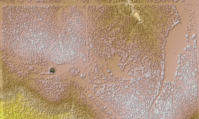
A prime example of the power of DSMs is a recent project where a European-based renewable energy company engaged with Prius Intelli to gather imagery and elevation data for a land acquisition project in New Mexico. The company was considering three acreage blocks located miles apart in remote areas of the state and needed to assess the suitability of the land for solar panel installation. Prius Intelli provided a cost-effective and efficient solution by conducting a fixed-wing flyover to support the development of orthographic maps, digital surface models (DSMs), and other terrain-related insight into each location.
The RGB orthophoto maps allowed for a preliminary analysis of the terrain to determine the presence of trees, bushes, bodies of water, and agricultural activity. The DSMs provided valuable insights into the overall flatness of the terrain, which is crucial for the ease of solar panel installation, and assisted in identifying potential drainage issues that may affect the stability of the solar panels or other infrastructure.
Full deliverables included:
-
- 5cm RGB imagery
-
-
- Digital Surface Models (DSM)
-
-
- DSM Hillshade
-
-
- Digital Elevation Models (DEM)
-
-
- DEM Hillshade
-
-
- Normalized Height Model
-
-
- Stream Networks
-
-
- Drainage Basins
-
-
- Contours
-
-
- Slope Model
-
Learn more about our digital elevation modeling services here.
Prius Intelli completed the flyovers and processed the data within the tight closing deadline (about three weeks), working between a spate of spring thunderstorms. The cost of the flyovers and GIS processing was roughly comparable to sending a single representative from Poland to New Mexico, without considering the work hours lost to travel. Moreover, a ground survey alone could not have captured the terrain-related information necessary to fully inform decision-making.
This case study demonstrates the power of combining high-resolution aerial imagery with digital surface models for land acquisition due diligence in the renewable energy sector. By leveraging Prius Intelli’s expertise in aerial imagery and elevation modeling, our client was able to make informed decisions about the suitability of the land for solar panel installation, ultimately leading to a successful project outcome.
Ready to harness the power of Digital Surface Models for your projects?
Contact Prius Intelli today to learn more about our cost-effective, high-resolution aerial imagery and DSM solutions tailored to your specific needs. Elevate your decision-making process with accurate terrain-related representations of the Earth’s surface and unlock new possibilities across various industries and applications.


In today’s rapidly evolving world, accurate and detailed representations of the Earth’s surface are crucial for informed decision-making across various industries. One such representation is the Digital Surface Model (DSM) that captures the elevations of all objects on the Earth’s surface, including vegetation, buildings, and infrastructure. In this blog post, we’ll explore how DSMs are created and then take a deep dive into how one European-based renewable energy company leveraged the power of DSMs and high-resolution aerial imagery to make critical decisions in a land acquisition project over 5,500 miles away.
How DSMs Are Created
When it comes to creating Digital Surface Models (DSMs) for industrial applications, two methods stand out as the most common and effective: LiDAR (Light Detection and Ranging) and Photogrammetry. Each method has its own advantages and considerations, making them suitable for a wide range of projects across various industries. In this section, we’ll take a closer look at how LiDAR and Photogrammetry work to create DSMs and how they can be leveraged to support informed decision-making.
-
- LiDAR (Light Detection and Ranging). LiDAR is a remote sensing method that uses laser pulses to measure the distance between the sensor and the Earth’s surface. Airborne or terrestrial laser scanning systems emit these pulses and measure the time taken for them to return, creating a dense point cloud of the surface. One of the main advantages of LiDAR is its ability to penetrate through vegetation and capture the bare earth terrain, making it ideal for creating Digital Elevation Models (DEMs) in addition to DSMs. LiDAR also provides high-resolution data, with point cloud densities ranging from a few points per square meter to hundreds of points per square meter. However, LiDAR data acquisition can be more expensive compared to other methods, and the processing of large point clouds requires specialized software and expertise.
-
-
- Photogrammetry. Photogrammetry is a technique that uses high-resolution aerial images taken from multiple angles to create models of the Earth’s surface. The parallax between the images is used to calculate the elevations of features, resulting in a DSM. One of the key advantages of photogrammetry is its cost-effectiveness. Prius Intelli’s 5cm resolution RGB orthoimagery produces highly accurate DSMs at a fraction of the cost of LiDAR. The imagery collected for photogrammetry can also be used for a wide variety of other project needs, such as GIS mapping, project planning, and visual oversight. Photogrammetry does have some limitations, however, such as its inability to penetrate through dense vegetation and its reliance on good lighting conditions and minimal shadowing for optimal results. Additionally, the accuracy of photogrammetry-derived DSMs may be lower than LiDAR-based models, particularly in areas with complex or steep terrain.
-
Case Study: Aerial Imagery and Digital Surface Models in Renewable Energy Land Acquisition
A prime example of the power of DSMs is a recent project where a European-based renewable energy company engaged with Prius Intelli to gather imagery and elevation data for a land acquisition project in New Mexico. The company was considering three acreage blocks located miles apart in remote areas of the state and needed to assess the suitability of the land for solar panel installation. Prius Intelli provided a cost-effective and efficient solution by conducting a fixed-wing flyover to support the development of orthographic maps, digital surface models (DSMs), and other terrain-related insight into each location.
The RGB orthophoto maps allowed for a preliminary analysis of the terrain to determine the presence of trees, bushes, bodies of water, and agricultural activity. The DSMs provided valuable insights into the overall flatness of the terrain, which is crucial for the ease of solar panel installation, and assisted in identifying potential drainage issues that may affect the stability of the solar panels or other infrastructure.
Full deliverables included:
-
- 5cm RGB imagery
-
-
- Digital Surface Models (DSM)
-
-
- DSM Hillshade
-
-
- Digital Elevation Models (DEM)
-
-
- DEM Hillshade
-
-
- Normalized Height Model
-
-
- Stream Networks
-
-
- Drainage Basins
-
-
- Contours
-
-
- Slope Model
-
Learn more about our digital elevation modeling services here.
Prius Intelli completed the flyovers and processed the data within the tight closing deadline (about three weeks), working between a spate of spring thunderstorms. The cost of the flyovers and GIS processing was roughly comparable to sending a single representative from Poland to New Mexico, without considering the work hours lost to travel. Moreover, a ground survey alone could not have captured the terrain-related information necessary to fully inform decision-making.
This case study demonstrates the power of combining high-resolution aerial imagery with digital surface models for land acquisition due diligence in the renewable energy sector. By leveraging Prius Intelli’s expertise in aerial imagery and elevation modeling, our client was able to make informed decisions about the suitability of the land for solar panel installation, ultimately leading to a successful project outcome.
Ready to harness the power of Digital Surface Models for your projects?
Contact Prius Intelli today to learn more about our cost-effective, high-resolution aerial imagery and DSM solutions tailored to your specific needs. Elevate your decision-making process with accurate terrain-related representations of the Earth’s surface and unlock new possibilities across various industries and applications.

