

Aerial Surveys & Structure ID: Easing the Burden of PHMSA Compliance
Aerial Surveys & Structure ID: Easing the Burden of PHMSA Compliance
Aerial Surveys & Structure ID: Easing the Burden of PHMSA Compliance
Aerial Surveys & Structure ID: Easing the Burden of PHMSA Compliance

Identifying structures for pipeline class location and HCA and MCA identification is a labor-intensive process that has been historically undertaken by ground crews. Prius Intelli’s all-new Structure ID® product package combines aerial surveys and structure digitization to deliver an easy, cost-effective answer for meeting compliance requirements.
With Phases Two and Three of the PHMSA Mega Rule taking effect in May of 2023, pipeline operators are facing a new reality where pipelines that previously did not fall under reporting scrutiny suddenly do. This means the manpower needed to complete US DOT-related structure identification requirements has increased simply because the number of US DOT-regulated pipelines has increased. This shift has left many midstream companies scrambling for solutions for how best to tackle the extra regulatory workload. In an industry suffering a seemingly endless labor crunch, hiring more people to take on this added work isn’t feasible, either practically or economically. Aerial surveys and an accompanying digitized structure identification process offer an efficient – and repeatable – answer.
Pipeline Classification & the Sliding Mile
Pipeline incidents in California in 2010 and in West Virginia two years later provided the primary push behind the eventual development of the “Mega Rule” that is seen in play today. Wishing to prevent future incidents, PHMSA has defined rules to implement greater monitoring and prevention measures.
The rule divides pipelines into mile-long segments defined by their proximity to structures and humans. Segments under section § 192.5 (a) are defined using a “sliding mile.” The sliding mile is a unit that is one mile long, extends 220 yards on either side of the centerline, and moves along the pipeline. Each mile is evaluated for the presence of various types of structures within that 220-yard boundary.
Per the Sliding Mile, PHMSA separates pipelines into four classes. Each class designation defines the number of inspections and maintenance measures required per year.
Sliding Mile – PHMSA Pipeline Classes
- Class 1: Any one-mile segment with 10 or fewer dwellings
- Class 2: Any one-mile segment with more than 10 and fewer than 46 dwellings
- Class 3: Any one-mile segment with more than 46 dwellings or in which there is intent to create human dwellings or associated outdoor areas such as parks, playgrounds, amphitheaters or any other feature that could be occupied by 20 or more people on at least 5 days in a week for 10 weeks in any 12-month period.
- Class 4: Any one-mile segment with a significant number of buildings at or taller than four stories above ground
PHMSA also divides pipeline segments into Medium Consequence areas (MCA) and High Consequence areas (HCA), which helps prioritize safety measures and regulations based on the potential impact of a pipeline incident. Factors that impact a segment’s MCA/HCA designation include population density, environmental considerations, pipeline type, and the product transported.
Identifying the number – and, more importantly, the type – of structures along the Sliding Mile is key to determining pipeline classification and associated consequence ratings.
Fixed-Wing Aerial Surveys & Structure ID
An aerial pipeline survey involves a fixed-wing, camera-equipped aircraft flying a pipeline’s centerline and designated 220-yard buffer to each side. High-resolution, geometrically corrected images are then provided that can be used for planning and ongoing operations, ROW clearing activities, documentation of ROW conditions before and after construction, encroachment detection, and pipeline As-Built Alignment Sheets.
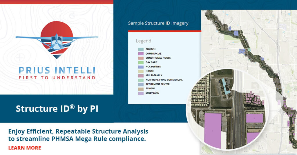
For pipeline owners and operators looking for a leg-up on regulatory compliance, Prius Intelli’ Structure ID® combines this centerline/buffer imagery with structure digitization. The outlines of structures that fall within the buffer are digitized, then classified to meet PHMSA population density analysis. GIS databases are provided that contain digitized polygons for each structure along with a code that defines the structure’s use. The resulting data provides the intelligence needed to efficiently – and repeatedly through change detection – identify US DOT Locations and High and Medium Consequence areas.
- Enjoy Efficient, Repeatable Structure Analysis to streamline PHMSA Mega Rule compliance with Structure ID by PI®.
Imagery is delivered within 2-4 weeks, weather dependent. Delivery time for structure digitization varies depending on the number of ROW miles flown. Subscription models are available. Contact our sales team for details.
It is important to note that aerial surveys do not completely eliminate the need for boots and eyeballs at ground level. Some situations still require human input. But by starting with aerial orthophotography and baseline structure identification, your people can zero in on specific questions. Their time becomes much more efficient, connecting the last few dots instead of gathering all the dots for the hundred-mile picture.
Get the Data You Need with Minimal Impact on Existing Resources
Embracing innovative approaches like aerial surveys and structure digitization can provide an efficient and repeatable method to meeting regulatory obligations. Prius Intelli’ Structure ID offers a truly turnkey solution, delivering the intelligence needed to identify US DOT Locations and High and Medium Consequence areas while minimizing the strain on existing resources. Put Structure ID by PI® to work for you today. Upload your pipe centerline file to get started.


Identifying structures for pipeline class location and HCA and MCA identification is a labor-intensive process that has been historically undertaken by ground crews. Prius Intelli’s all-new Structure ID® product package combines aerial surveys and structure digitization to deliver an easy, cost-effective answer for meeting compliance requirements.
With Phases Two and Three of the PHMSA Mega Rule taking effect in May of 2023, pipeline operators are facing a new reality where pipelines that previously did not fall under reporting scrutiny suddenly do. This means the manpower needed to complete US DOT-related structure identification requirements has increased simply because the number of US DOT-regulated pipelines has increased. This shift has left many midstream companies scrambling for solutions for how best to tackle the extra regulatory workload. In an industry suffering a seemingly endless labor crunch, hiring more people to take on this added work isn’t feasible, either practically or economically. Aerial surveys and an accompanying digitized structure identification process offer an efficient – and repeatable – answer.
Pipeline Classification & the Sliding Mile
Pipeline incidents in California in 2010 and in West Virginia two years later provided the primary push behind the eventual development of the “Mega Rule” that is seen in play today. Wishing to prevent future incidents, PHMSA has defined rules to implement greater monitoring and prevention measures.
The rule divides pipelines into mile-long segments defined by their proximity to structures and humans. Segments under section § 192.5 (a) are defined using a “sliding mile.” The sliding mile is a unit that is one mile long, extends 220 yards on either side of the centerline, and moves along the pipeline. Each mile is evaluated for the presence of various types of structures within that 220-yard boundary.
Per the Sliding Mile, PHMSA separates pipelines into four classes. Each class designation defines the number of inspections and maintenance measures required per year.
Sliding Mile – PHMSA Pipeline Classes
- Class 1: Any one-mile segment with 10 or fewer dwellings
- Class 2: Any one-mile segment with more than 10 and fewer than 46 dwellings
- Class 3: Any one-mile segment with more than 46 dwellings or in which there is intent to create human dwellings or associated outdoor areas such as parks, playgrounds, amphitheaters or any other feature that could be occupied by 20 or more people on at least 5 days in a week for 10 weeks in any 12-month period.
- Class 4: Any one-mile segment with a significant number of buildings at or taller than four stories above ground
PHMSA also divides pipeline segments into Medium Consequence areas (MCA) and High Consequence areas (HCA), which helps prioritize safety measures and regulations based on the potential impact of a pipeline incident. Factors that impact a segment’s MCA/HCA designation include population density, environmental considerations, pipeline type, and the product transported.
Identifying the number – and, more importantly, the type – of structures along the Sliding Mile is key to determining pipeline classification and associated consequence ratings.
Fixed-Wing Aerial Surveys & Structure ID
An aerial pipeline survey involves a fixed-wing, camera-equipped aircraft flying a pipeline’s centerline and designated 220-yard buffer to each side. High-resolution, geometrically corrected images are then provided that can be used for planning and ongoing operations, ROW clearing activities, documentation of ROW conditions before and after construction, encroachment detection, and pipeline As-Built Alignment Sheets.
For pipeline owners and operators looking for a leg-up on regulatory compliance, Prius Intelli’ Structure ID® combines this centerline/buffer imagery with structure digitization. The outlines of structures that fall within the buffer are digitized, then classified to meet PHMSA population density analysis. GIS databases are provided that contain digitized polygons for each structure along with a code that defines the structure’s use. The resulting data provides the intelligence needed to efficiently – and repeatedly through change detection – identify US DOT Locations and High and Medium Consequence areas.
- Enjoy Efficient, Repeatable Structure Analysis to streamline PHMSA Mega Rule compliance with Structure ID by PI®.
Imagery is delivered within 2-4 weeks, weather dependent. Delivery time for structure digitization varies depending on the number of ROW miles flown. Subscription models are available. Contact our sales team for details.
It is important to note that aerial surveys do not completely eliminate the need for boots and eyeballs at ground level. Some situations still require human input. But by starting with aerial orthophotography and baseline structure identification, your people can zero in on specific questions. Their time becomes much more efficient, connecting the last few dots instead of gathering all the dots for the hundred-mile picture.
Get the Data You Need with Minimal Impact on Existing Resources
Embracing innovative approaches like aerial surveys and structure digitization can provide an efficient and repeatable method to meeting regulatory obligations. Prius Intelli’ Structure ID offers a truly turnkey solution, delivering the intelligence needed to identify US DOT Locations and High and Medium Consequence areas while minimizing the strain on existing resources. Put Structure ID by PI® to work for you today. Upload your pipe centerline file to get started.

