

Updated Aerial & GIS Data Informs Pipeline Route Planning
Updated Aerial & GIS Data Informs Pipeline Route Planning
Updated Aerial & GIS Data Informs Pipeline Route Planning
Updated Aerial & GIS Data Informs Pipeline Route Planning

Pipeline route planning of new infrastructure has its challenges, whether the line carries crude oil, natural gas, NGLs, refined products, or water of any sort. This is especially true when it crosses property lines, county jurisdictions, and fences. Navigating the landscape of both legal and physical obstacles can be challenging.
With physical barriers, those objects can change overnight. It’s one reason that relying on satellite data (Google Earth), which can be months out of date, can cause planners to miss new fences, roads, or buildings. Alternatively, you can send people out to drive the route—which is expensive and, by the time you drive the whole route, things there might have changed.
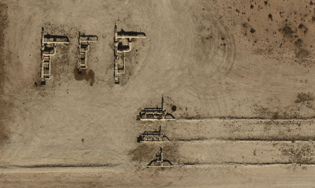
Prius Intelli’s aerial data and GIS mapping give you up-to-date surface data for accurate planning, letting you prepare for obstacles you find. Some clients use this for two passes in the planning stage. One at the start, to make the preliminary plan—then a final run just before construction starts, to detect any last-minute changes—maybe before they become permanent.
Accuracy for Pipeline Route Planning
Our aerial imagery is accurate to within a few inches, meaning it will closely match survey lines, for mapping purposes.
There is a surprising benefit to using elevation data, which involves gauging “true distance.” This comes into play in hilly areas. A straight line on a map may be significantly shorter, not accounting for the ups and downs of hills and other contours of the land. This difference can materially affect the amount of pipe required for the completion of the project. No one wants to come to the end and realize they are 100 feet short of connecting to the intended facility. With today’s supply chain issues, this small error could delay a project by weeks.
Another benefit to elevation information is that it can inform the placement of compressor or pump stations in order to send product over a hill.
Leak Pinpointing
The days of flying a small plane with a specially mounted camera over an existing pipeline route looking for leaks are fading fast. Rapidly improving remote sensors and monitoring systems are alerting operators to problems as soon as they start.
Even so, sometimes it can be necessary to pinpoint a leak’s exact location and extent before dispatching a repair crew. Prius Intelli can do exactly that.
Leak Class Verification for High Consequence Areas
In order to identify areas needing the highest priority of safety measure, the Pipeline and Hazardous Materials Safety Administration (PHMSA) has delineated four classes of locations. The lowest levels are numbered 1 and 2, which are essentially in remote spots. Class 4 areas are within close proximity to the high population and structures densities.
These numbers are used for determining high consequence areas (HCAs), information that must be reviewed at regular intervals. The HCA classification directly correlates to the amount of monitoring and hazard response preparedness required for any location.
Aerial photography can provide this data quickly and efficiently. Some visual inspection may still be required in certain areas to measure exact distances, but the aerial view can show operators exactly where to look.
These are just some of the ways aerial and GIS data can quickly benefit midstream operations. To learn more about how Prius Intelli can quickly get you the details you need, click here.


Pipeline route planning of new infrastructure has its challenges, whether the line carries crude oil, natural gas, NGLs, refined products, or water of any sort. This is especially true when it crosses property lines, county jurisdictions, and fences. Navigating the landscape of both legal and physical obstacles can be challenging.
With physical barriers, those objects can change overnight. It’s one reason that relying on satellite data (Google Earth), which can be months out of date, can cause planners to miss new fences, roads, or buildings. Alternatively, you can send people out to drive the route—which is expensive and, by the time you drive the whole route, things there might have changed.
Prius Intelli’s aerial data and GIS mapping give you up-to-date surface data for accurate planning, letting you prepare for obstacles you find. Some clients use this for two passes in the planning stage. One at the start, to make the preliminary plan—then a final run just before construction starts, to detect any last-minute changes—maybe before they become permanent.
Accuracy for Pipeline Route Planning
Our aerial imagery is accurate to within a few inches, meaning it will closely match survey lines, for mapping purposes.
There is a surprising benefit to using elevation data, which involves gauging “true distance.” This comes into play in hilly areas. A straight line on a map may be significantly shorter, not accounting for the ups and downs of hills and other contours of the land. This difference can materially affect the amount of pipe required for the completion of the project. No one wants to come to the end and realize they are 100 feet short of connecting to the intended facility. With today’s supply chain issues, this small error could delay a project by weeks.
Another benefit to elevation information is that it can inform the placement of compressor or pump stations in order to send product over a hill.
Leak Pinpointing
The days of flying a small plane with a specially mounted camera over an existing pipeline route looking for leaks are fading fast. Rapidly improving remote sensors and monitoring systems are alerting operators to problems as soon as they start.
Even so, sometimes it can be necessary to pinpoint a leak’s exact location and extent before dispatching a repair crew. Prius Intelli can do exactly that.
Leak Class Verification for High Consequence Areas
In order to identify areas needing the highest priority of safety measure, the Pipeline and Hazardous Materials Safety Administration (PHMSA) has delineated four classes of locations. The lowest levels are numbered 1 and 2, which are essentially in remote spots. Class 4 areas are within close proximity to the high population and structures densities.
These numbers are used for determining high consequence areas (HCAs), information that must be reviewed at regular intervals. The HCA classification directly correlates to the amount of monitoring and hazard response preparedness required for any location.
Aerial photography can provide this data quickly and efficiently. Some visual inspection may still be required in certain areas to measure exact distances, but the aerial view can show operators exactly where to look.
These are just some of the ways aerial and GIS data can quickly benefit midstream operations. To learn more about how Prius Intelli can quickly get you the details you need, click here.

