

4 Planning Use Cases for Aerial Planimetric Mapping
4 Planning Use Cases for Aerial Planimetric Mapping
4 Planning Use Cases for Aerial Planimetric Mapping
4 Planning Use Cases for Aerial Planimetric Mapping

Before starting a land-based project on any significant scale, it’s vital to know what objects are already on the landscape. Knowing the exact size, dimensions and placement of things like roads, buildings, power lines, and other items allows planners place new construction while accounting for what’s already there.
Planimetric Mapping
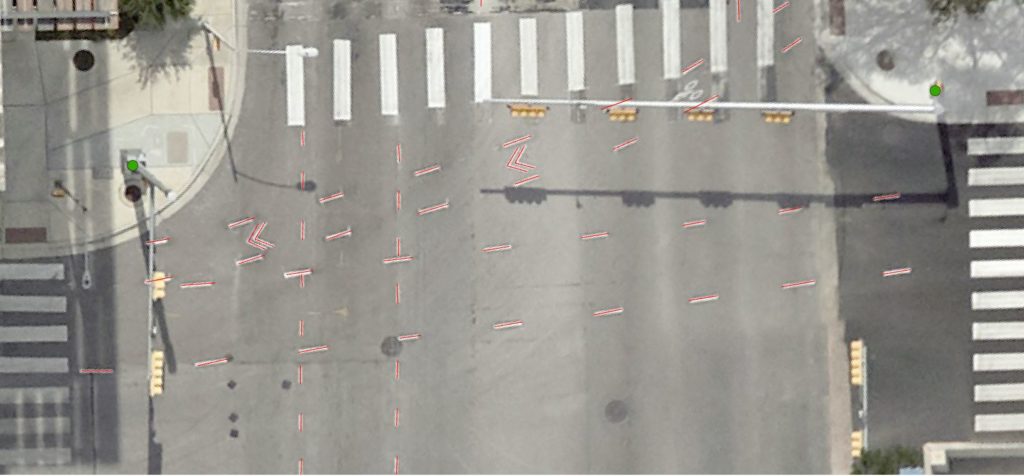
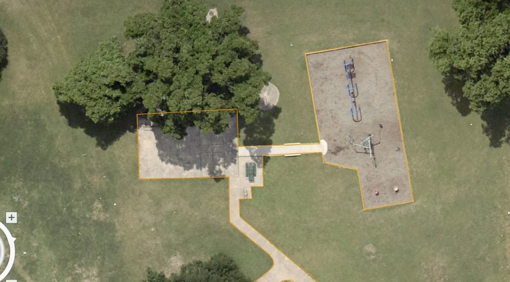
Aerially obtained planimetric mapping from high quality aerial photos is the most accurate and efficient way to get this data. Planimetric mapping is a type of map that outlines only the horizontal position of existing features on the earth’s surface, such as roads, buildings, bodies of water, and other man-made or natural features. Map features can be as detailed as showing manhole covers and curbs. For project planners, the maps show exact dimensions and location, making it easy to visualize the ways new features fit the landscape. The data can be uploaded into geographic information systems (GIS), providing levels of detail that can simplify project planning.
Planimetric mapping outlines existing features, giving their exact dimensions and location. It can also include natural features such as rivers, lakes, mountains, and valleys.
Use Cases for Planimetric Data
Placing new common carriers such as power lines and pipelines requires great planning, often over long distances. Working around existing features is important in acquiring right of way (ROW). In addition, midstream companies constructing pipelines for hazardous materials such as petroleum, natural gas or refined products have another layer of concern, which regards nearby population safety.
Pipelines
The Pipelines and Hazardous Materials Safety Administration (PHMSA) classifies pipeline safety requirements by proximity to population. It does this on a scale from 1-4, in ascending order of density, one being the lowest. For levels three and four, PHMSA requires additional safety measures in case of a leak.
Planimetric mapping can help decision-makers locate those level 3-4 areas. That allows them to make an informed decision about either exploring re-routing options or budgeting for level 3-4 safety measures.
Utility Planning and Maintenance
Companies connecting new power generation sites to end-user populations use planimetric mapping for a number of things in addition to identifying geographic features. They also gauge the distance between the new wind farm, solar array, or geothermal station and the main power grid. Here too there are regulations regarding the location of high power lines in relation to populous areas. And certainly rivers, highways, and hills/valleys must be accounted for.
Historic Site Preservation
Some historic sites spread over acres and are centered on waterways or forests. Aerial planimetric mapping can quickly identify changes in water courses, lake levels or land erosion—things that could threaten irreplaceable structures. Managers can then decide on what preservation measures to take.
Visualizing Terrain
Putting a camera aloft to get the “bird’s eye view” of large areas is nothing new. More than 100 years ago photographers mounted cameras on kites or helium balloons. Aerial planimetric mapping advances that idea by quantifying sizes and distances related to terrain features for every purpose. Aerial photography (specifically, geometrically corrected orthoimagery) is what powers planimetric data, giving you incredible insight for land-based projects.
Prius Intelli’s Advantages
Some planners use satellite or drone data photography, but both have drawbacks. Satellite imagery may not be current, may be partially obscured by clouds, or may be lacking in fine details. Drones can only cover small areas at a time and must be operated by an on-site person. This can be time-consuming and costly.
Prius Intelli uses aircraft to quickly, closely, and economically cover large areas—an option especially vital to mega projects such as pipelines and power grids. We can provide data from one square mile to several thousand, in the detail you need, at 2.5, 5, 7.5, 10, or 15 CM.
Freshly collected on demand—exactly when you need it—we deliver your data within a few days.


Before starting a land-based project on any significant scale, it’s vital to know what objects are already on the landscape. Knowing the exact size, dimensions and placement of things like roads, buildings, power lines, and other items allows planners place new construction while accounting for what’s already there.
Planimetric Mapping
Aerially obtained planimetric mapping from high quality aerial photos is the most accurate and efficient way to get this data. Planimetric mapping is a type of map that outlines only the horizontal position of existing features on the earth’s surface, such as roads, buildings, bodies of water, and other man-made or natural features. Map features can be as detailed as showing manhole covers and curbs. For project planners, the maps show exact dimensions and location, making it easy to visualize the ways new features fit the landscape. The data can be uploaded into geographic information systems (GIS), providing levels of detail that can simplify project planning.
Planimetric mapping outlines existing features, giving their exact dimensions and location. It can also include natural features such as rivers, lakes, mountains, and valleys.
Use Cases for Planimetric Data
Placing new common carriers such as power lines and pipelines requires great planning, often over long distances. Working around existing features is important in acquiring right of way (ROW). In addition, midstream companies constructing pipelines for hazardous materials such as petroleum, natural gas or refined products have another layer of concern, which regards nearby population safety.
Pipelines
The Pipelines and Hazardous Materials Safety Administration (PHMSA) classifies pipeline safety requirements by proximity to population. It does this on a scale from 1-4, in ascending order of density, one being the lowest. For levels three and four, PHMSA requires additional safety measures in case of a leak.
Planimetric mapping can help decision-makers locate those level 3-4 areas. That allows them to make an informed decision about either exploring re-routing options or budgeting for level 3-4 safety measures.
Utility Planning and Maintenance
Companies connecting new power generation sites to end-user populations use planimetric mapping for a number of things in addition to identifying geographic features. They also gauge the distance between the new wind farm, solar array, or geothermal station and the main power grid. Here too there are regulations regarding the location of high power lines in relation to populous areas. And certainly rivers, highways, and hills/valleys must be accounted for.
Historic Site Preservation
Some historic sites spread over acres and are centered on waterways or forests. Aerial planimetric mapping can quickly identify changes in water courses, lake levels or land erosion—things that could threaten irreplaceable structures. Managers can then decide on what preservation measures to take.
Visualizing Terrain
Putting a camera aloft to get the “bird’s eye view” of large areas is nothing new. More than 100 years ago photographers mounted cameras on kites or helium balloons. Aerial planimetric mapping advances that idea by quantifying sizes and distances related to terrain features for every purpose. Aerial photography (specifically, geometrically corrected orthoimagery) is what powers planimetric data, giving you incredible insight for land-based projects.
Prius Intelli’s Advantages
Some planners use satellite or drone data photography, but both have drawbacks. Satellite imagery may not be current, may be partially obscured by clouds, or may be lacking in fine details. Drones can only cover small areas at a time and must be operated by an on-site person. This can be time-consuming and costly.
Prius Intelli uses aircraft to quickly, closely, and economically cover large areas—an option especially vital to mega projects such as pipelines and power grids. We can provide data from one square mile to several thousand, in the detail you need, at 2.5, 5, 7.5, 10, or 15 CM.
Freshly collected on demand—exactly when you need it—we deliver your data within a few days.

