

Using Aerial Imagery to Overcome Labor Shortage 2023
Using Aerial Imagery to Overcome Labor Shortage 2023
Using Aerial Imagery to Overcome Labor Shortage 2023
Using Aerial Imagery to Overcome Labor Shortage 2023

Labor Shortage 2023
The oil and gas industry—probably including your company—is dealing with the same labor shortage in 2023 as everyone from fast food to health care. It’s frustrating when there are things to be done, but they’re delayed because there are not enough people to do them in a timely fashion.
And that’s not likely to change anytime soon. You’ve seen the headlines: Employees Are Going to Have the Upper Hand for Years; U.S. Shale Executives Concerned About Labor Shortages; and on and on.
Your opportunities for growth continue, but they’re stymied by the tight labor market. You’re drilling new wells, which need new pad sites. You’re growing your midstream network to keep up with new oil and gas production. You’re building a new gas plant. But in your own company’s labor shortage, you lack the people to go there and gather information on terrain, existing structures, nearby roads/powerlines/population fast enough to meet deadlines.
Aerial Imagery Helps Fill in Labor Gaps
You’ve seen the waiting lists for frac jobs, workovers, wireline and every other type of service work in the industry. Waiting for surveys and data needed in site selection is just one more delay you’d have to face—if not for the availability of aerial imagery.
This issue gets bigger with larger surveys. Planning pipeline routes can involve surveying and inspecting hundreds of miles. That is especially true when considering alternative routes around population centers or other obstacles. It could require weeks or months to gather and process the data before it’s useful for decision making. Those delays are costly both in person-hours and in pushing back the profitability of the project.
Using aerial imagery, we can cover areas from a single square mile to thousands of square miles in a few days. We can provide detail at 2.5, 5, 7.5, 10, or 15 CM. While aerial imagery can’t replace a ground survey, aerial imagery gives the great detail needed for extensive preliminary planning. Instead of waiting for ground surveys to kick off your project, you can have a survey team queued up and ready to go when you’ve determined the route.
What You Can See Only with Aerial Data
An Actual Overhead Picture
There’s nothing like actually seeing the landscape to give you and your planners the true feel of the land’s possibilities. Coordinates and elevations are important, but they’re sometimes too abstract. “Seeing is believing” and from the air you can understand proximity of obstacles, changes in elevation, and the true demands of the job ahead. Even if you could hire dozens of people, they could never give you the real bird’s eye view. Here are some examples of what you can only get from aerial data.
An Orthographically Correct Assessment
Without correction, even the best camera has issues with perspective—items around the edges often appear smaller or more stretched out than those toward the center. Applying orthography to photos, as we do, gives you the true relationship of size and distance between objects. It’s like looking at a flat map.
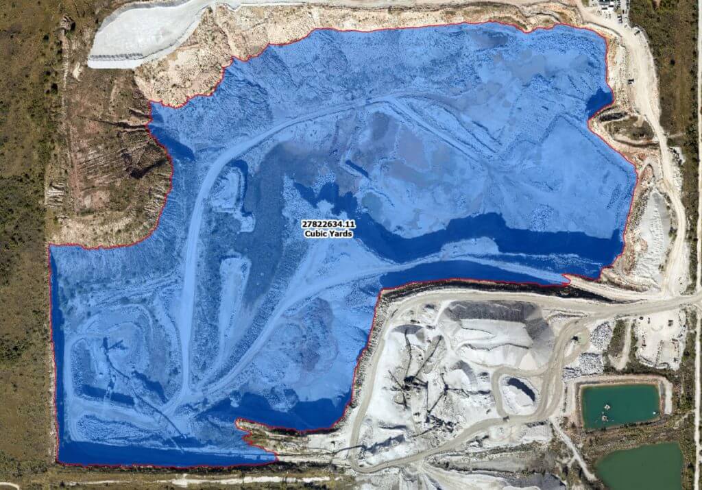
You can accurately place new structures at the appropriate distances; you can correctly measure perimeters; you can assess the amount of fencing or pipe or other supplies needed for every aspect of the job. Even if you had full labor force participation, that would take months to measure every item. It would take even more time to compile it all manually.
Interlocked Photos of an Extensive Area
When evaluating a 100-mile gas pipeline route, we can connect our aerial photos into a seamless continuum. That way you can scroll through and connect the measurements you need to assess the total length and size of the project without manually adding or multiplying numbers. We make our data available in a variety of formats. That way you can plug it into systems you already have, making your own evaluations.
Instantly Identifying Updates
For most projects that take a few months or a couple of years to permit and build, the geography can change during that time. Houses and other structures are built or torn down. A rainstorm can wash out a bridge or some driveways. Range or forest fires can change the boundaries of vegetation. Also, since manual data collection requires many weeks, some of the original data could change over that time. Even the first report could be outdated.
Instead, a single flyover can supply all the updates. Data processing can quickly assess and flag any changes, without eyestrain or magnifying glasses.
What It Means to You
We collect our imagery on a per-order basis. Our normal turnaround time from receipt of the order to delivery of the imagery is 2-4 weeks. We offer several delivery options, including WMS/WMTS and links to the tiff files.
We also leverage the imagery to develop quality derivative work products. Some examples include vector data from the RGB, or elevation data in the way of contour lines, elevation models, stream networks, drainage basins, etc. alongside the RGB imagery.
No matter the extent of your people shortage, you get accurate, complete and timely data from Prius Intelli in time to move your project forward.
Contact us at 888-717-6277 to learn more.


Labor Shortage 2023
The oil and gas industry—probably including your company—is dealing with the same labor shortage in 2023 as everyone from fast food to health care. It’s frustrating when there are things to be done, but they’re delayed because there are not enough people to do them in a timely fashion.
And that’s not likely to change anytime soon. You’ve seen the headlines: Employees Are Going to Have the Upper Hand for Years; U.S. Shale Executives Concerned About Labor Shortages; and on and on.
Your opportunities for growth continue, but they’re stymied by the tight labor market. You’re drilling new wells, which need new pad sites. You’re growing your midstream network to keep up with new oil and gas production. You’re building a new gas plant. But in your own company’s labor shortage, you lack the people to go there and gather information on terrain, existing structures, nearby roads/powerlines/population fast enough to meet deadlines.
Aerial Imagery Helps Fill in Labor Gaps
You’ve seen the waiting lists for frac jobs, workovers, wireline and every other type of service work in the industry. Waiting for surveys and data needed in site selection is just one more delay you’d have to face—if not for the availability of aerial imagery.
This issue gets bigger with larger surveys. Planning pipeline routes can involve surveying and inspecting hundreds of miles. That is especially true when considering alternative routes around population centers or other obstacles. It could require weeks or months to gather and process the data before it’s useful for decision making. Those delays are costly both in person-hours and in pushing back the profitability of the project.
Using aerial imagery, we can cover areas from a single square mile to thousands of square miles in a few days. We can provide detail at 2.5, 5, 7.5, 10, or 15 CM. While aerial imagery can’t replace a ground survey, aerial imagery gives the great detail needed for extensive preliminary planning. Instead of waiting for ground surveys to kick off your project, you can have a survey team queued up and ready to go when you’ve determined the route.
What You Can See Only with Aerial Data
An Actual Overhead Picture
There’s nothing like actually seeing the landscape to give you and your planners the true feel of the land’s possibilities. Coordinates and elevations are important, but they’re sometimes too abstract. “Seeing is believing” and from the air you can understand proximity of obstacles, changes in elevation, and the true demands of the job ahead. Even if you could hire dozens of people, they could never give you the real bird’s eye view. Here are some examples of what you can only get from aerial data.
An Orthographically Correct Assessment
Without correction, even the best camera has issues with perspective—items around the edges often appear smaller or more stretched out than those toward the center. Applying orthography to photos, as we do, gives you the true relationship of size and distance between objects. It’s like looking at a flat map.
You can accurately place new structures at the appropriate distances; you can correctly measure perimeters; you can assess the amount of fencing or pipe or other supplies needed for every aspect of the job. Even if you had full labor force participation, that would take months to measure every item. It would take even more time to compile it all manually.
Interlocked Photos of an Extensive Area
When evaluating a 100-mile gas pipeline route, we can connect our aerial photos into a seamless continuum. That way you can scroll through and connect the measurements you need to assess the total length and size of the project without manually adding or multiplying numbers. We make our data available in a variety of formats. That way you can plug it into systems you already have, making your own evaluations.
Instantly Identifying Updates
For most projects that take a few months or a couple of years to permit and build, the geography can change during that time. Houses and other structures are built or torn down. A rainstorm can wash out a bridge or some driveways. Range or forest fires can change the boundaries of vegetation. Also, since manual data collection requires many weeks, some of the original data could change over that time. Even the first report could be outdated.
Instead, a single flyover can supply all the updates. Data processing can quickly assess and flag any changes, without eyestrain or magnifying glasses.
What It Means to You
We collect our imagery on a per-order basis. Our normal turnaround time from receipt of the order to delivery of the imagery is 2-4 weeks. We offer several delivery options, including WMS/WMTS and links to the tiff files.
We also leverage the imagery to develop quality derivative work products. Some examples include vector data from the RGB, or elevation data in the way of contour lines, elevation models, stream networks, drainage basins, etc. alongside the RGB imagery.
No matter the extent of your people shortage, you get accurate, complete and timely data from Prius Intelli in time to move your project forward.
Contact us at 888-717-6277 to learn more.

