

Ethan Sparks, Vice President of Solutions, featured in The Journal of Petroleum Technology
Ethan Sparks, Vice President of Solutions, featured in The Journal of Petroleum Technology
Ethan Sparks, Vice President of Solutions, featured in The Journal of Petroleum Technology
Ethan Sparks, Vice President of Solutions, featured in The Journal of Petroleum Technology

Prius Intelli’s Vice President of Solutions, Ethan Sparks, was recently featured in The Journal of Petroleum Technology to give an in-depth discussion of the many uses of aerial imagery in the oil and gas industry. Ethan’s expertise and innovation is helping oil and gas industry operators save both time and money across a wide range of activities. Below is a brief synopsis of the article.
The oil and gas industry is facing increasing costs and a shrinking workforce, prompting energy companies to adopt new technologies to improve efficiency and accelerate project schedules. Aerial photography has emerged as a powerful solution, replacing time-consuming in-person data collection over vast distances. With the use of aerial imagery, a single fixed-wing flyover can cover hundreds of miles in a few hours, significantly reducing costs and gathering time. The technology can be applied for various tasks such as site selection and exploration, planning and design, environmental impact assessment, pipeline planning and monitoring, safety and security, asset monitoring, and compliance with environmental regulations.
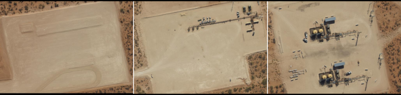
Aerial photography provides high-resolution images of the landscape, enabling detailed analysis of terrain, vegetation, and geological features. This data aids in making informed decisions about drilling pad locations, pipeline routes, and other infrastructure, minimizing environmental impact and maximizing operational efficiency. Furthermore, aerial surveys assist in emergency response planning, ongoing monitoring of pipeline integrity, and compliance with safety standards set by regulatory agencies like the Department of Transportation’s Pipeline Hazardous Materials Safety Administration (PHMSA). The use of aerial imagery streamlines processes, helps predict future infrastructure needs, and allows energy companies to keep all stakeholders informed and connected regardless of their location. Overall, aerial photography proves to be an invaluable tool for the oil and gas industry, enabling better planning, cost reduction, and improved project execution.
Read the full article here: https://jpt.spe.org/aerial-imagery-expedites-planning-and-monitoring-of-oil-and-gas-facilities.


Prius Intelli’s Vice President of Solutions, Ethan Sparks, was recently featured in The Journal of Petroleum Technology to give an in-depth discussion of the many uses of aerial imagery in the oil and gas industry. Ethan’s expertise and innovation is helping oil and gas industry operators save both time and money across a wide range of activities. Below is a brief synopsis of the article.
The oil and gas industry is facing increasing costs and a shrinking workforce, prompting energy companies to adopt new technologies to improve efficiency and accelerate project schedules. Aerial photography has emerged as a powerful solution, replacing time-consuming in-person data collection over vast distances. With the use of aerial imagery, a single fixed-wing flyover can cover hundreds of miles in a few hours, significantly reducing costs and gathering time. The technology can be applied for various tasks such as site selection and exploration, planning and design, environmental impact assessment, pipeline planning and monitoring, safety and security, asset monitoring, and compliance with environmental regulations.
Aerial photography provides high-resolution images of the landscape, enabling detailed analysis of terrain, vegetation, and geological features. This data aids in making informed decisions about drilling pad locations, pipeline routes, and other infrastructure, minimizing environmental impact and maximizing operational efficiency. Furthermore, aerial surveys assist in emergency response planning, ongoing monitoring of pipeline integrity, and compliance with safety standards set by regulatory agencies like the Department of Transportation’s Pipeline Hazardous Materials Safety Administration (PHMSA). The use of aerial imagery streamlines processes, helps predict future infrastructure needs, and allows energy companies to keep all stakeholders informed and connected regardless of their location. Overall, aerial photography proves to be an invaluable tool for the oil and gas industry, enabling better planning, cost reduction, and improved project execution.
Read the full article here: https://jpt.spe.org/aerial-imagery-expedites-planning-and-monitoring-of-oil-and-gas-facilities.

