

Aerial Imagery & GIS Can Improve Sand Mining & Other Surface Mining Operations
Aerial Imagery & GIS Can Improve Sand Mining & Other Surface Mining Operations
Aerial Imagery & GIS Can Improve Sand Mining & Other Surface Mining Operations
Aerial Imagery & GIS Can Improve Sand Mining & Other Surface Mining Operations

In today’s market, operational efficiency is the key to success for aggregate surface mining operations everywhere—whether it’s sand mining for oil and gas, caliche mining for roads in infrastructure or other types. As costs rise and investors demand greater returns, mining operations are digging for actionable information as much as they’re digging for product.
One area of efficiency that might be overlooked is in inventory management. This can apply to existing and active mines, but it can also apply to planned expansions or completely new locations. How does a mining company get details on how much land has been moved and what percentage of that is salable product? What is another tool they can use to evaluate a new location?
The Impact of Aerial Photography & GIS Mapping
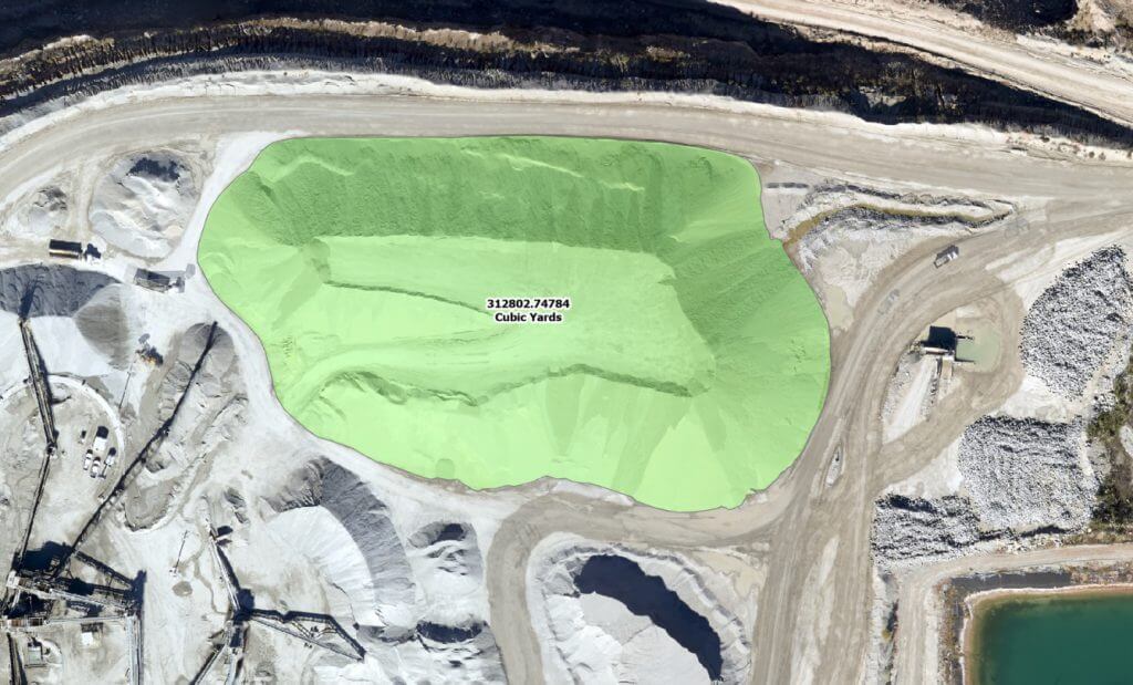
Using detailed aerial photography and GIS mapping to measure elevation changes it is possible to calculate the amount of ground removed. This can then be compared to the amount of product shipped to determine what percent is salable product and what is waste.
For example, in calculating that 100,000 acre-feet of removed dirt produced 98,000 acre-feet of usable sand gives clients valuable efficiency information. This data can then be used to estimate remaining salable inventory, along with recovery costs for a single mine. Miners with multiple operations can compare locations to determine relative costs and where to focus investment and planning.
GIS data can also help miners evaluate and compare prospective locations for new mines, helping calculate the area and density of product deposits.
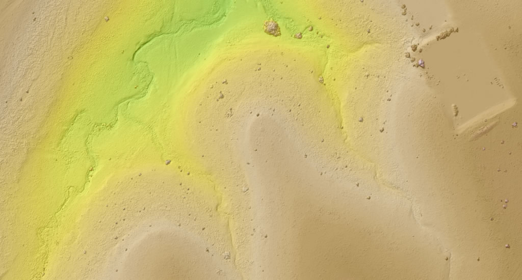
Use Cases for Elevation Contour Maps
Prius Intelli can provide detailed elevation contours for any given area, giving details on:
Vegetation/Canopy Density: to evaluate what must be removed at the start;
Watershed and Drainage: vital to managing runoff and containing spills and protecting people and machinery from sloughing. Change detection involving land surrounding a location can alert operators of possible changes in runoff to or from their operation;
Infrastructure Planning: such as the location of connecting roads and power lines, helpful with new locations;
Surface/Construction: As new locations are being set up, it can be difficult to make sure drainage, roads, and pits are in line with specifications. Detailed aerial and GIS data, collected as work progresses, can help place such issues or remediate anything mistakes while earth movers are still on site.
As Much Detail as You Need
We collect our imagery using manned fixed-wing aircraft equipped with state-of-the-art sensors capable of resolutions ranging from 2.5-15 cm. This provides current, crisp data on any project. For GIS mapping, we process the information through advanced analytics to provide comprehensive base maps with geospatial data and analysis.
Insight Is 2020
At Prius Intelli, we’re revolutionizing the geospatial industry. Our manned, fixed-wing aircraft can cover thousands of square miles in a short time, carrying specialized sensors capable of much more detail than is available from drones. Combined with our GIS intelligence, you get useful data configured in a variety of ways depending on exactly what you need. It’s data you can use to become more efficient, maximize extraction operations and accurately plan for the future. Contact us to learn more.
Follow Prius Intelli on LinkedIn.


In today’s market, operational efficiency is the key to success for aggregate surface mining operations everywhere—whether it’s sand mining for oil and gas, caliche mining for roads in infrastructure or other types. As costs rise and investors demand greater returns, mining operations are digging for actionable information as much as they’re digging for product.
One area of efficiency that might be overlooked is in inventory management. This can apply to existing and active mines, but it can also apply to planned expansions or completely new locations. How does a mining company get details on how much land has been moved and what percentage of that is salable product? What is another tool they can use to evaluate a new location?
The Impact of Aerial Photography & GIS Mapping
Using detailed aerial photography and GIS mapping to measure elevation changes it is possible to calculate the amount of ground removed. This can then be compared to the amount of product shipped to determine what percent is salable product and what is waste.
For example, in calculating that 100,000 acre-feet of removed dirt produced 98,000 acre-feet of usable sand gives clients valuable efficiency information. This data can then be used to estimate remaining salable inventory, along with recovery costs for a single mine. Miners with multiple operations can compare locations to determine relative costs and where to focus investment and planning.
GIS data can also help miners evaluate and compare prospective locations for new mines, helping calculate the area and density of product deposits.
Use Cases for Elevation Contour Maps
Prius Intelli can provide detailed elevation contours for any given area, giving details on:
Vegetation/Canopy Density: to evaluate what must be removed at the start;
Watershed and Drainage: vital to managing runoff and containing spills and protecting people and machinery from sloughing. Change detection involving land surrounding a location can alert operators of possible changes in runoff to or from their operation;
Infrastructure Planning: such as the location of connecting roads and power lines, helpful with new locations;
Surface/Construction: As new locations are being set up, it can be difficult to make sure drainage, roads, and pits are in line with specifications. Detailed aerial and GIS data, collected as work progresses, can help place such issues or remediate anything mistakes while earth movers are still on site.
As Much Detail as You Need
We collect our imagery using manned fixed-wing aircraft equipped with state-of-the-art sensors capable of resolutions ranging from 2.5-15 cm. This provides current, crisp data on any project. For GIS mapping, we process the information through advanced analytics to provide comprehensive base maps with geospatial data and analysis.
Insight Is 2020
At Prius Intelli, we’re revolutionizing the geospatial industry. Our manned, fixed-wing aircraft can cover thousands of square miles in a short time, carrying specialized sensors capable of much more detail than is available from drones. Combined with our GIS intelligence, you get useful data configured in a variety of ways depending on exactly what you need. It’s data you can use to become more efficient, maximize extraction operations and accurately plan for the future. Contact us to learn more.
Follow Prius Intelli on LinkedIn.

