

Understanding Cloud Coverage Options in Aerial Imagery: Balancing Aesthetics and Efficiency
Understanding Cloud Coverage Options in Aerial Imagery: Balancing Aesthetics and Efficiency
Understanding Cloud Coverage Options in Aerial Imagery: Balancing Aesthetics and Efficiency
Understanding Cloud Coverage Options in Aerial Imagery: Balancing Aesthetics and Efficiency

At Prius Intelli, we believe in empowering our clients with the knowledge to make informed decisions. When it comes to aerial imagery, cloud cover is a natural part of the process that primarily affects the aesthetic appearance of your images. Today, we’re exploring how different levels of cloud cover influence your aerial imagery and the options we offer to ensure you get the results you need, when you need them.
The Aesthetic Impact of Cloud Cover
Cloud cover in aerial imagery mainly influences the visual appearance of your data:
- Lighting Variations: Cloud shadows can create subtle changes in brightness across the image.
- Visual Consistency: Different cloud conditions may affect the overall look of the imagery, particularly across large areas.
- Contrast: Interestingly, overcast days often provide excellent conditions for imagery, offering consistent lighting and minimal shadows.
It’s important to note that in most cases, cloud cover does not significantly impact the technical quality or usability of the data for analysis and decision-making purposes.
Our Flexible Approach to Cloud Cover
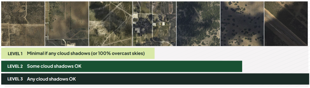
At Prius Intelli, we understand that each project has unique requirements and timelines. To accommodate these needs, we offer three levels of cloud cover options:
LEVEL 1: Minimal Cloud Shadows (or 100% Overcast)
- Offers the most visually consistent appearance
LEVEL 2: Some Cloud Shadows Acceptable
- May show occasional variations in lighting across the image
- Suitable for most projects, offering a balance between visual consistency and efficient data collection
LEVEL 3: Any Cloud Shadows Acceptable
- May result in more noticeable lighting variations across the imagery
- Ideal when rapid data collection is the primary concern
Choosing the Right Option for Your Project
When deciding on the acceptable level of cloud cover for your project, consider:
- Visual Requirements: If your project benefits from a highly uniform visual appearance, LEVEL 1 might be your preference.
- Project Flexibility: Many projects can achieve excellent results with LEVEL 2 conditions, offering more opportunities for timely data collection.
- Time Sensitivity: For urgent projects where quick data delivery is crucial, LEVEL 3 allows for the most flexible collection windows.
- Seasonal Factors: In areas prone to frequent cloud cover, being open to LEVEL 2 or 3 can significantly reduce potential delays in data collection.
Altitude, Resolution, and Cloud Cover: What You Need to Know
The resolution you select for your project directly influences our collection altitude: lower resolution imagery allows us to fly higher, while higher resolution requires lower altitudes. This becomes crucial when dealing with cloud cover. If clouds are below our standard collection altitude, we may not be able to capture lower resolution imagery (such as 10-15 cm) because the clouds would obstruct our view of the ground. However, higher resolution options (like 5-7.5 cm) enable us to fly below the clouds, still collecting clear, unobstructed data.
Flexible Upgrade Option: For time-sensitive projects, we offer a proactive solution:
- You can choose to upgrade to higher resolution imagery in advance.
- This upgrade is noted in your flight plan.
- If low clouds are present during the scheduled flight, our pilots are pre-authorized to fly at a lower altitude.
- This flexibility ensures we capture clear, unobstructed imagery of the ground, even in challenging weather conditions.
- If weather conditions allow us to collect at your original resolution, you won’t incur any additional charges.
Pro Tip: This upgrade option is particularly valuable for urgent projects in areas prone to low cloud cover, as it minimizes potential weather-related delays.
Discuss with your Prius Intelli representative to determine the best resolution and altitude options for your specific project needs and local weather conditions.
The Prius Intelli Approach: Tailored to Your Needs
We believe in a collaborative approach to ensure you get the best possible results:
- We discuss your project requirements, timelines, and preferences.
- Together, we determine the most suitable cloud cover level for your needs.
- Our team incorporates this decision into your project plan.
- We collect your data under the agreed conditions, optimizing for both aesthetic quality and efficient delivery.
Your Choice, Our Commitment
We understand that you know your project needs best. Your Prius Intelli representative will work closely with you to understand your preferences and requirements. Whether you prioritize visual consistency, flexibility, or rapid delivery, we’re here to support your decision and provide the best possible results within your chosen parameters.
Conclusion
Understanding your cloud cover options empowers you to make choices that best suit your project’s unique needs. By selecting the appropriate level, you can balance visual aesthetics with efficient data collection and timely delivery.
At Prius Intelli, we’re committed to delivering high-quality aerial imagery that meets your project requirements. Our flexible approach to cloud cover ensures that you get the data you need, when you need it, without unnecessary delays.
Have questions about cloud cover options or any other aspects of your aerial imagery project? Don’t hesitate to reach out to your Prius Intelli representative. We’re here to help you achieve clear results, no matter the sky conditions!
At Prius Intelli, we believe in empowering our clients with the knowledge to make informed decisions. When it comes to aerial imagery, cloud cover is a natural part of the process that primarily affects the aesthetic appearance of your images. Today, we’re exploring how different levels of cloud cover influence your aerial imagery and the options we offer to ensure you get the results you need, when you need them.
The Aesthetic Impact of Cloud Cover
Cloud cover in aerial imagery mainly influences the visual appearance of your data:
- Lighting Variations: Cloud shadows can create subtle changes in brightness across the image.
- Visual Consistency: Different cloud conditions may affect the overall look of the imagery, particularly across large areas.
- Contrast: Interestingly, overcast days often provide excellent conditions for imagery, offering consistent lighting and minimal shadows.
It’s important to note that in most cases, cloud cover does not significantly impact the technical quality or usability of the data for analysis and decision-making purposes.
Our Flexible Approach to Cloud Cover
At Prius Intelli, we understand that each project has unique requirements and timelines. To accommodate these needs, we offer three levels of cloud cover options:
LEVEL 1: Minimal Cloud Shadows (or 100% Overcast)
- Offers the most visually consistent appearance
LEVEL 2: Some Cloud Shadows Acceptable
- May show occasional variations in lighting across the image
- Suitable for most projects, offering a balance between visual consistency and efficient data collection
LEVEL 3: Any Cloud Shadows Acceptable
- May result in more noticeable lighting variations across the imagery
- Ideal when rapid data collection is the primary concern
Choosing the Right Option for Your Project
When deciding on the acceptable level of cloud cover for your project, consider:
- Visual Requirements: If your project benefits from a highly uniform visual appearance, LEVEL 1 might be your preference.
- Project Flexibility: Many projects can achieve excellent results with LEVEL 2 conditions, offering more opportunities for timely data collection.
- Time Sensitivity: For urgent projects where quick data delivery is crucial, LEVEL 3 allows for the most flexible collection windows.
- Seasonal Factors: In areas prone to frequent cloud cover, being open to LEVEL 2 or 3 can significantly reduce potential delays in data collection.
Altitude, Resolution, and Cloud Cover: What You Need to Know
The resolution you select for your project directly influences our collection altitude: lower resolution imagery allows us to fly higher, while higher resolution requires lower altitudes. This becomes crucial when dealing with cloud cover. If clouds are below our standard collection altitude, we may not be able to capture lower resolution imagery (such as 10-15 cm) because the clouds would obstruct our view of the ground. However, higher resolution options (like 5-7.5 cm) enable us to fly below the clouds, still collecting clear, unobstructed data.
Flexible Upgrade Option: For time-sensitive projects, we offer a proactive solution:
- You can choose to upgrade to higher resolution imagery in advance.
- This upgrade is noted in your flight plan.
- If low clouds are present during the scheduled flight, our pilots are pre-authorized to fly at a lower altitude.
- This flexibility ensures we capture clear, unobstructed imagery of the ground, even in challenging weather conditions.
- If weather conditions allow us to collect at your original resolution, you won’t incur any additional charges.
Pro Tip: This upgrade option is particularly valuable for urgent projects in areas prone to low cloud cover, as it minimizes potential weather-related delays.
Discuss with your Prius Intelli representative to determine the best resolution and altitude options for your specific project needs and local weather conditions.
The Prius Intelli Approach: Tailored to Your Needs
We believe in a collaborative approach to ensure you get the best possible results:
- We discuss your project requirements, timelines, and preferences.
- Together, we determine the most suitable cloud cover level for your needs.
- Our team incorporates this decision into your project plan.
- We collect your data under the agreed conditions, optimizing for both aesthetic quality and efficient delivery.
Your Choice, Our Commitment
We understand that you know your project needs best. Your Prius Intelli representative will work closely with you to understand your preferences and requirements. Whether you prioritize visual consistency, flexibility, or rapid delivery, we’re here to support your decision and provide the best possible results within your chosen parameters.
Conclusion
Understanding your cloud cover options empowers you to make choices that best suit your project’s unique needs. By selecting the appropriate level, you can balance visual aesthetics with efficient data collection and timely delivery.
At Prius Intelli, we’re committed to delivering high-quality aerial imagery that meets your project requirements. Our flexible approach to cloud cover ensures that you get the data you need, when you need it, without unnecessary delays.
Have questions about cloud cover options or any other aspects of your aerial imagery project? Don’t hesitate to reach out to your Prius Intelli representative. We’re here to help you achieve clear results, no matter the sky conditions!

